The Listing Said Power Was Available. The Lines Were Transmission.
Power lines along a parcel don't mean usable power. How to tell transmission from distribution lines, and what one power line easement took on a real parcel.
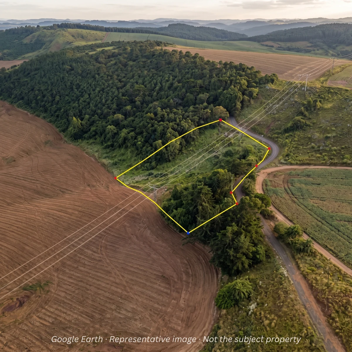
The listing said power was available.
The realtor saw power lines along the road. The buyer saw power lines along the road. The parcel was rural, in Oregon’s Willamette Valley, and from the truck window it looked obvious.
Tall power lines along a parcel don’t mean the parcel has usable power. Transmission lines move bulk electricity at high voltage between plants and substations. Distribution lines carry the lower-voltage power that reaches a house, after a transformer steps it down. A line with no transformer and no wire running to a building isn’t serving anybody.
Then a SiteFacts Report came in.
How do you tell transmission lines from distribution lines?
As soon as we looked at the property in satellite imagery, the lines raised a red flag. They were too high, too widely spaced, and there were no transformers anywhere along the run.
Those weren’t distribution lines serving nearby homes. They were transmission lines. The U.S. Energy Information Administration’s overview of electricity delivery lays out the two separate systems and the substation step down that has to happen before power reaches a house.
That meant the power everyone thought was sitting at the property wasn’t available for residential service.
One caution. These tells assume overhead service and a simple two tier grid. Underground residential distribution uses padmount transformers at ground level instead of poles, and a mid voltage tier called sub-transmission can look like either neighbor. Treat what you see as a reason to ask, never as a certification.
How much land can a power line easement take?
It depends on the easement, so there is no general answer. Here is what one transmission easement took on this parcel.
Then we opened the survey.
The transmission corridor carried a substantial easement across the property. Once we mapped it against the parcel, roughly two-thirds of the site was effectively unavailable for the buyer’s proposed development.
So the thing the realtor and buyer had looked at as an asset turned out to be two separate problems. The lines couldn’t serve the property, and the easement associated with them consumed most of the usable land.
A survey shows what a drive-by can’t. The recorded easement sets its width and terms, and a survey shows where it sits on the lot. Check both on any lot. We covered the same kind of gap in The Landlocked Lot That Wasn’t.
What did the utility say?
We contacted the utility to find the nearest point the property could actually be served from. About half a mile away. The extension, easements and equipment were estimated at roughly $70,000.
That is one utility’s estimate for one specific gap, not a rate for every lot. A line extension is the new distribution line, poles and transformer a utility builds out from its nearest existing service to reach a new site.
The project died, and the buyer sold the land at a loss.
Who sets the price of a line extension?
In Oregon, the cost of extending an electric line is generally set in each utility’s own tariff, approved by the Oregon Public Utility Commission. Each utility files its own, so the terms on one parcel can differ from the next.
Electric cooperatives and people’s utility districts are consumer-owned and may fall outside the state commission’s rate review, so ask the utility which line extension policy applies.
Whoever serves the parcel, ask that utility for a written estimate. A tariff on file with the state does not replace that call.
How early does a builder need to ask?
Before design starts. Electrical service planning is the top action item in site feasibility work, and power planning is the most common cause of construction delays in our work. Power planning should start 6 to 12 months before construction is intended to begin.
Our power planning guide walks through the stages.
What carries over to your next deal
On this Willamette Valley parcel, a SiteFacts Report found three things a drive-by missed. Satellite imagery showed transmission lines, not distribution lines. The survey showed an easement that left roughly two-thirds of the site effectively unavailable for the buyer’s proposed development. And the utility’s nearest point of service was about half a mile away, with the extension, easements and equipment estimated at roughly $70,000. That is one parcel and one utility’s estimate, not a rate for every lot. The questions carry over: what is the line, can it serve the site, and what else comes with it.
Nothing about the power lines was hidden. Everyone could see them. The problem was knowing what you were looking at.
That is why a SiteFacts Report goes beyond checking whether a utility line appears to be near the property. We want to know what it is, whether it can actually serve the site, and what else comes with it. For a builder whose customer brings the lot, that answer comes before the floor plan and before the contract.
To rough in utility and infrastructure costs before you have quotes, the Land Development Cost Calculator gives budget ranges. It doesn’t replace a utility’s written estimate.
Power is power, until it isn’t. On the next lot that arrives with power lines in view, order a SiteFacts Report and know what the line is, whether it can serve the site and what else comes with it before your customer commits.
Know what the line is before the floor plan
The SiteFacts Report looks past whether a utility line appears near the property: what it is, whether it can serve the site, and what else comes with it.
Related reading
 Due Diligence
What Land Buyers Find Out Too Late
The listing isn't wrong. The city isn't wrong. Nobody asked the next question. Here's what slope, zoning, and utilities can cost when you find them after the offer instead of before.
Read Land Buying
Beyond the Sale Price: How Location Affects Your Home's True Cost
Two neighboring Oregon counties, the same house, a $312,600 difference over 30 years. Where you build sets the permit fees and property taxes the sale price never shows.
Read Due Diligence
Don't Trust the Fence: Why a Land Survey Is a Must Before You Buy
A fence is not a property line. It just looks like one. On a tight lot, that gap can erase your entire build, and a survey is the only way to know before you're stuck with it.
Read