This Lot Fronts a Public Road. It May Be Landlocked Anyway.
A lot on a paved county road may still have no approvable driveway. A 1990s survey, a voided plat process and a missing easement show how it happens.
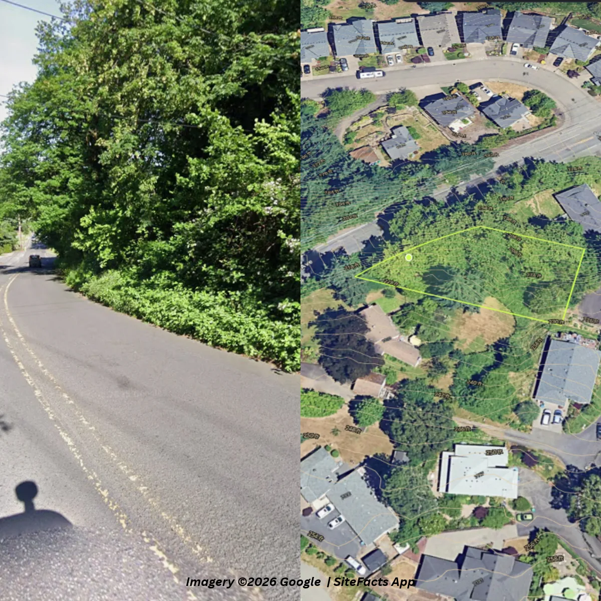
When a lot fronts a public road, it’s easy to assume access is a given. This one fronts a paved county road, and it may be landlocked anyway.
A lot on a public road can still have no approvable driveway. Frontage gives a lot a road to touch, but the road authority still decides whether a driveway can be approved, and a back route across someone else’s land generally depends on a recorded easement or other legal right, which a title search confirms. A lot with frontage, a failed driveway check and no recorded easement has no confirmed way in, whatever it looks like from the street.
The reason is in the records, not on the ground. SiteFacts research found a 1997 record of survey whose own note says the parcels shown “do not become legal parcels by virtue of being depicted hereon,” and that the easements shown “are proposed, unless noted otherwise.” A recorded 30 ft private access and utility easement runs from the cul-de-sac behind the lot up to the neighbor’s property line, and it stops there. SiteFacts research found no record of the connecting piece across the neighbor’s lot. So this lot has legal frontage on a public road and potentially no approvable way in.
The lot that looked like a sure thing
A builder ordered a SiteFacts Report on a vacant lot outside Portland, Oregon. About 0.31 acres, never built on, in unincorporated county land inside the urban growth boundary, zoned residential. Houses on every side.
The lot was created by a partition recorded in 1994, 32 years ago. It fronts a paved public county road, on a curve. On a quick look this is a normal infill lot.
Most of us check the box on access when the lot sits on a public road, and move on to utilities and zoning. That is the assumption this post is about. Utilities and zoning are real questions. They just come second to the question of whether a driveway can legally reach the lot at all.
The clue in the old survey
The 1997 record of survey was drawn for a proposed partition. It showed a lot line adjustment, access easements, and a private lane connecting the lot to a cul-de-sac behind it. In plain terms, drawing a parcel on a survey doesn’t make it a parcel.
Someone in the 1990s worked hard to build a route in from the back of a lot that already sits on a public road. People don’t do that for no reason.
The survey’s own note explains part of it. It says the survey was filed because recording of the partition plat was delayed. SiteFacts research found the county later voided that partition plat process, which is separate from the 1994 partition that created the lot. The county’s current tax map still shows the original 1994 lot lines, and SiteFacts research found no record that the lot line adjustment was ever completed.
The road itself
Back to the front of the lot. Nearly the entire frontage is a steep embankment above the road. There is one small corner where a driveway might physically fit.
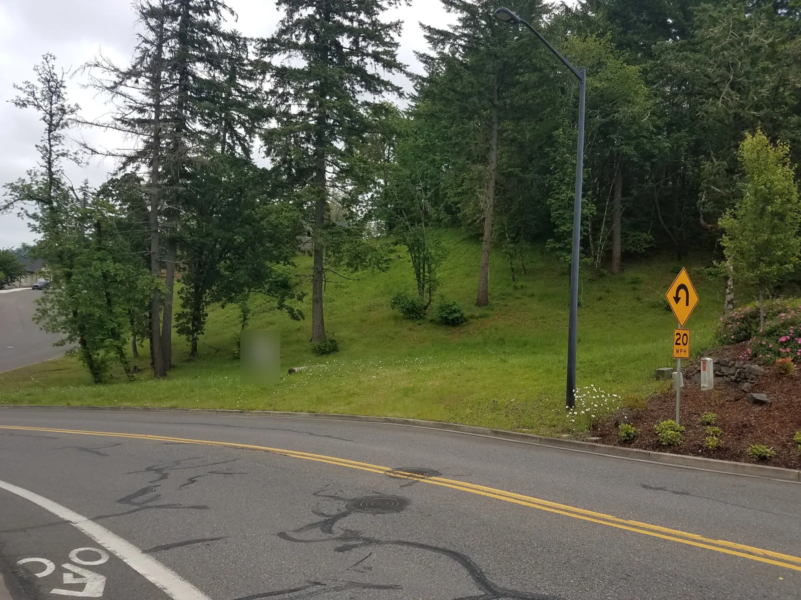
A different lot from an earlier site visit, on the same kind of curve.
This is one county’s case, with one county’s standards. Road authorities (county, city or state DOT) set their own driveway permit rules and sight-distance standards, and they differ, so confirm yours. The Federal Highway Administration’s access management overview describes access as governed by policies from state and local agencies that have permit authority, along with land development regulations that address property access.
Here, the county’s roadway standards base driveway sight distance on the AASHTO design policy, and say access that doesn’t meet the criteria is subject to denial, removal or modification. A driveway that fails can be denied. The standards allow a lesser sight distance in limited cases under a separate section, and nothing says that applies here. The same standards cap average residential driveway grade at 12 percent, with no paved section steeper than 20 percent.
Whether that one corner clears sight distance and grade is a question the county answers, after someone measures it on the ground. We can’t answer it from a desk, and neither can the builder’s sales rep.
The back door that was never finished
With the front in doubt, the back route matters. The recorded easement from the cul-de-sac stops at the neighbor’s line. SiteFacts research found the subject lot holds no rights under that easement or under any easement across the neighbor’s lot.
That is where the “proposed” easements on the 1997 survey come in. They look official on a surveyor’s drawing. SiteFacts research found no recorded easement to match them, and no record that the lot line adjustment that would have tied the lot to them was completed.
Finding a recorded easement, or finding that one is missing, takes deed and plat research across more than the subject parcel. Here is how that research turned up a recorded easement on a Florida lot priced as landlocked. On this lot the research ran the other way.
Even the fix costs money
Say the neighbor agrees to record the missing piece. The back route still isn’t free.
A long access route from the cul-de-sac brings fire access requirements into play. Depending on what the fire authority approves, that can mean a turnaround or sprinklers in the house. Oregon’s fire code is adopted by the Oregon State Fire Marshal, and the local fire authority makes the call on a specific driveway.
Access wasn’t the only finding. The report also flagged parts of the lot as highly susceptible to landslides on the state geology agency’s landslide mapping. Slopes average 16 percent and reach 36 percent on a heavily treed lot, and sewer and water connections were still unconfirmed.
What it means for a builder
A builder who signs a build contract on this lot can’t price the site work. A builder also can’t confirm a path to a permit until a neighbor, a surveyor and the county all say yes. Those are three parties the builder doesn’t control, and the customer is already waiting on a start date. On a lot like this, the floor plan can fit on paper and the contract can look routine. Nothing in that sequence asks how the driveway gets from the road to the garage.
Finding that after the contract is signed is the expensive way to learn it. Finding it during due diligence gives you options: price it, redesign around it, negotiate the easement, or walk away. Those usually cost less before a customer has your name on a contract.
How to check access before contract
None of this needs a special tool to start. These six checks are worth running on any lot, and the answers vary by jurisdiction.
- Confirm who controls the road (county, city or state) and whether a driveway or approach permit is required.
- On curves, hills and busy roads, ask the road authority about sight distance before assuming a driveway location works.
- Check whether the slope from the road to the lot allows a driveway within allowable grades.
- Don’t trust easements shown on a survey. Confirm recorded easements in deeds or a title report.
- Compare the current tax map against older surveys and plats. Differences point to unfinished or voided plans.
- If the house will sit far from the road, ask the fire authority about access distance, turnarounds and sprinklers.
The road was never hidden. Neither was the embankment. The answer was sitting in a decades-old survey that nobody had a reason to pull, because the lot was on a public road.
A SiteFacts Report pulls the historical permit records and cites every finding back to the official source. On this lot, the research also compared the current tax map against the 1997 survey, which is how the gap surfaced. It identifies constraints. It doesn’t survey the lot, design a driveway or secure an easement. The SiteFacts App gives a quick first look at parcel info, zoning, setbacks, floodplains, wetlands and slope, but records and easements come from a Report. Find the issue during due diligence and you still have options.
Before you sign on your next lot, submit it for a SiteFacts Report.