Your Customer's Lot Is in a Flood Zone. Can You Build? A Builder's Step-by-Step Guide
Building in a flood zone or floodplain starts with a local permit and a surveyor. Eight steps from map check to final certificate, in plain words.
Last reviewed: 2026-11-05. Flood rules change and vary by jurisdiction. Confirm with your local floodplain administrator.
A customer brings you a lot and a floor plan. The listing never mentioned a flood zone, or the customer saw the map and figured it was a small problem. Now you have to work out whether you can build, and how, before you quote a price.
Building in a mapped flood zone, also called a floodplain, is usually possible. First you need a floodplain development permit from the local jurisdiction.
The federal rule, 44 CFR 60.3 in the Code of Federal Regulations (CFR), makes participating communities require one in mapped A zones. The house also has to sit at or above a set height.
Plan on a surveyor, an elevation certificate, flood vents or an elevated floor system, and careful fill planning.
Table of contents
- What does it take to build in a flood zone?
- Is it worth building in a floodplain?
- Step 0: Is the lot in a flood zone, and does the customer know?
- Step 1: Which flood map is current for my lot?
- Step 2: What is a floodplain development permit?
- Step 3: Do I need a surveyor?
- Step 4: How high does the floor need to be above the base flood elevation?
- What does Zone A mean when the map shows no BFE?
- Step 5: Can floor joists or a crawlspace sit below the BFE?
- Do utilities have to be above the BFE?
- Can I have a basement in a flood zone?
- Step 6: Can I bring in fill?
- Step 7: How do I keep a septic tank from floating?
- Step 8: What happens at the end of construction?
- Does meeting code keep flood insurance low?
- What is the FEMA 50 percent rule?
- Can I get my lot out of the flood zone?
- What a SiteFacts Report does here
- Terms on this page
| Step | What closes it | Who to call |
|---|---|---|
| Step 0: Lot check | Address checked on the Flood Map Service Center of the Federal Emergency Management Agency (FEMA), floodplain office called | Local floodplain office |
| Step 1: Flood map | Current effective FIRM (Flood Insurance Rate Map) panel, with panel number and date | FEMA’s Flood Map Service Center, then the floodplain administrator |
| Step 2: Permit | Floodplain development permit | Floodplain administrator |
| Step 3: Surveyor | Base flood elevation (BFE) stake, and the elevation certificate (EC) at the stage the jurisdiction requires | Licensed surveyor |
| Step 4: Floor height | Freeboard number, which is the extra height above the BFE | Floodplain administrator |
| Step 5: Materials | Confirmed that materials below the BFE, flood openings and equipment location meet the local rules | Floodplain administrator |
| Step 6: Fill | Local approval for any fill | Floodplain administrator |
| Step 7: Septic | Tank anchoring detail | Licensed septic designer and the local permitting office |
| Step 8: Final | Final (as-built) EC | Licensed surveyor and the floodplain administrator |
In this series:
- Part 1, this guide.
- Part 2: Elevation Certificates, on timing, cost and what gets measured.
- Part 3: Flood Vents, on requirements and how many you need.
- Part 4: Flood Insurance, on why meeting code does not set your premium.
- Part 5: LOMA vs LOMR-F, on getting a lot out of the flood zone.
- Part 6: How to Build a House in a Flood Zone, on design decisions in order, from floor height to stairs.
- Part 7: Floodplain Development Permit, on what the permit covers, what goes in the application and how review works.
What does it take to build in a flood zone?
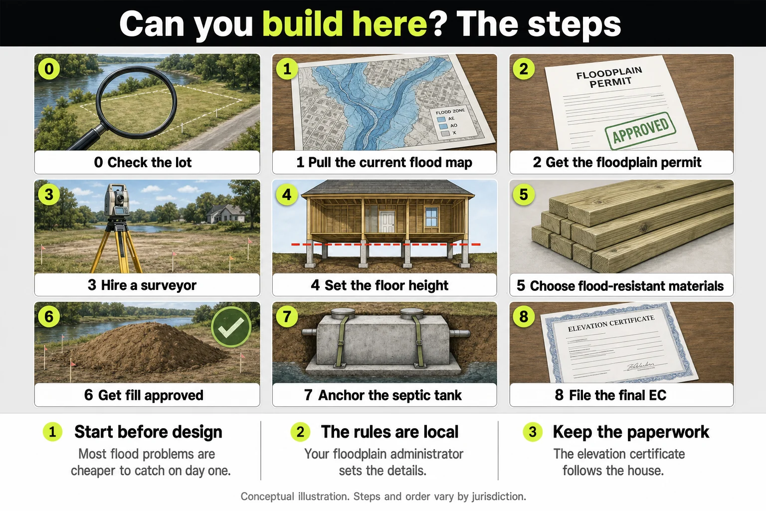
Eight steps, in the order a builder works them out: check the map, get the local permit, hire a surveyor, set the floor height, choose materials, plan any fill, protect the septic tank, and close out with a final certificate.
FEMA, the Federal Emergency Management Agency, sets the federal minimums for communities in the National Flood Insurance Program, or NFIP. Your city or county adopts them, can make them stricter, and issues the permit. Under 44 CFR 60.1(d), a section of the Code of Federal Regulations, a state or local rule that is more restrictive takes precedence over the federal criteria.
Your floodplain administrator, the local official who runs the program, has the final word.
Part 6 shows how these pieces fit together on one house, in the order the decisions get made: how to build a house in a flood zone.
Is it worth building in a floodplain?
It can be, when the lot is priced for the extra work. In a mapped flood zone, that work is the local permit, surveyor visits and elevation certificates, the required floor height, limits on fill, and a flood insurance quote that meeting code does not set.
Know each of those before your customer commits to the lot, so your quote reflects the work.
Take the steps below in order. The SiteFacts Report section shows what a Report covers on the lot and what it leaves to a surveyor and the floodplain administrator.
Step 0: Is the lot in a flood zone, and does the customer know?
Check before the first design conversation. Search the lot’s address on FEMA’s Flood Map Service Center and call the local floodplain office.
The high-risk kind of flood zone is called the Special Flood Hazard Area, or SFHA. It is the land FEMA maps as having a 1 percent chance of flooding in any given year.
The base flood elevation, or BFE, is the height floodwater reaches in a flood with a 1 percent chance of happening in any year, according to FEMA’s glossary.
Three ideas come up often.
- The listing said there is no flood zone.
- Fill will fix it.
- Insurance will be normal if the house is built to code.
Step 1 shows whether the lot is mapped and whether the listing’s map information is current. Step 6 answers the second, and the insurance section the third.
Step 1: Which flood map is current for my lot?
Pull the current effective FIRM panel for the lot, and write down the panel number and its effective date. The FIRM, or Flood Insurance Rate Map, is the map FEMA publishes for each community. A zone letter alone is not enough.
Maps change. FEMA’s own site warns that what you download or print may be superseded by new maps over time.
So pull the panel when the customer brings you the lot, and again before design and before you apply for the permit. Ask the floodplain administrator whether a map update, a Letter of Map Revision (LOMR, which changes the map itself), or a local study is pending. For what each zone letter means, see our post on flood zones before you buy.
Examples: Oregon map history
In Lane County, Oregon, the floodplain code, as amended in 2021, adopts FIRM panels in one ordinance, and those panels carry effective dates of both 1999 and 2020, according to Ordinance 21-07.
On Oregon’s McKenzie River, FEMA’s pending flood map update was issued as preliminary maps in early 2020, the September 2020 Holiday Farm Fire changed the watershed, and the preliminary data has been reissued since. A map you pulled for one purchase may not be the one that governs your permit.
Plain words for your customer: “The map tells us the zone. It doesn’t tell us how high your lot sits, and it can change between now and your permit. We’ll pull the current map today and again before we design.”
Step 2: What is a floodplain development permit?
It is a local permit that sets how you can develop in the floodplain. In our experience, the process ranges widely, from a simple planning review to a full conditional use permit. It comes first because it governs everything after it.
Part 7 covers what the permit covers and how to get one.
Under 44 CFR 60.3(b)(1) and (c)(1), participating communities must require permits for all proposed construction and other development in mapped A zones, with or without a published BFE. That covers Zone A, AE, A1-30, AH and AO. How the permit works is up to the community.
Examples: Idaho and Lane County
Idaho shows the range. In Garden City, work that is exempt and outside the floodway needs only a Minor Work Floodplain Permit with an application form.
A floodway is the channel and nearby land that has to stay clear to carry a flood. Grading or placing fill in the floodplain, or work in the floodway, takes the full floodplain and floodway application.
Ada County, Idaho, adds a sequencing rule. You may apply for a building permit at the same time, but Ada County’s page says the building permit will not be issued until the County Engineer approves the floodplain permit.
Lane County shows the range inside one code. Its ordinance requires a development permit before construction in the high-risk area, including for fill, and says new homes must be located outside the SFHA unless the applicant shows that is infeasible.
Some of those cases go through a Type I review, and cases that need judgment go through a discretionary Type II review. That is in Ordinance 21-07, and it covers unincorporated Lane County only.
Step 3: Do I need a surveyor?
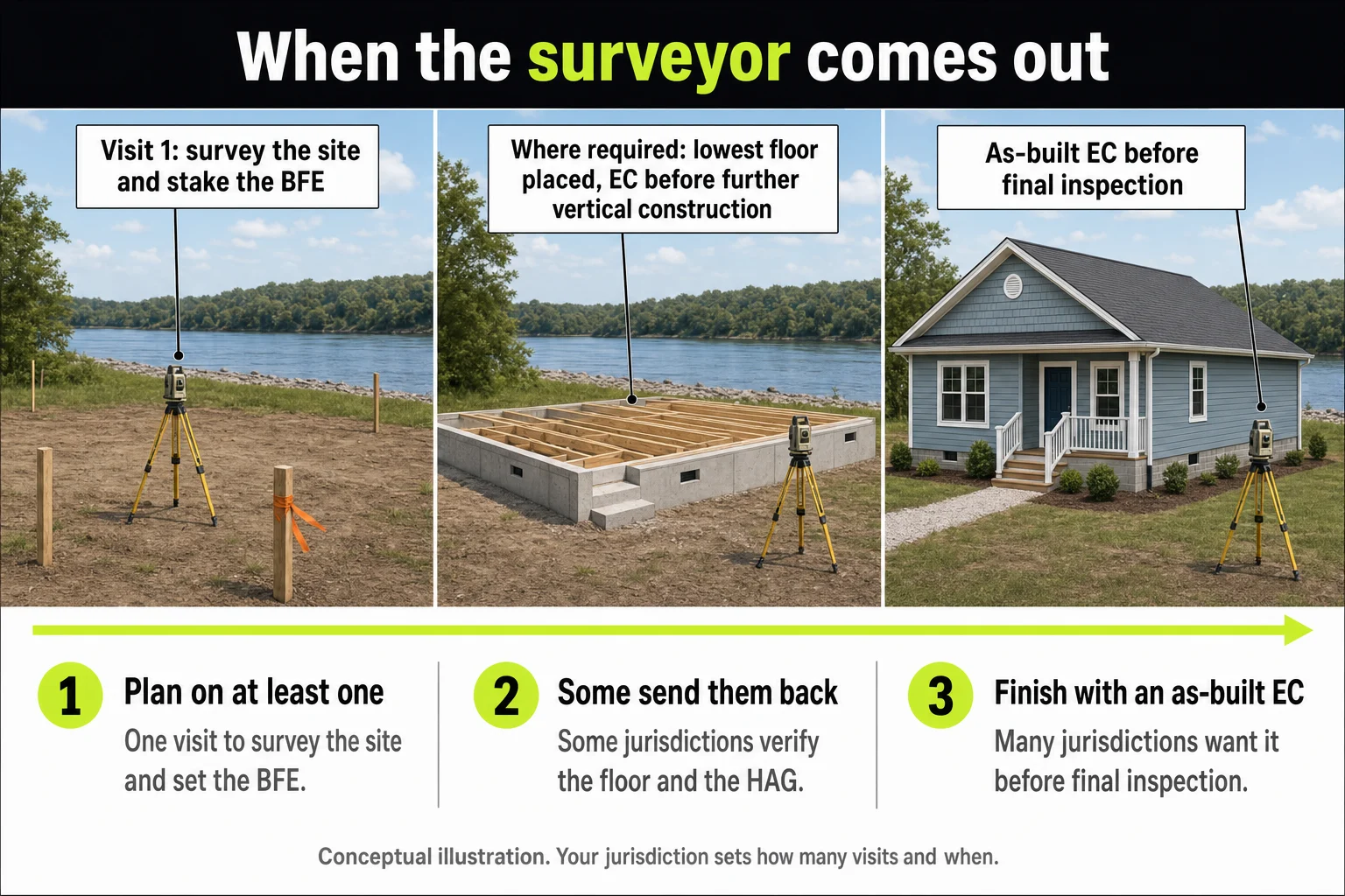
Yes. A licensed surveyor provides the elevation certificate, or EC, the FEMA form that records how high a building sits compared with the base flood elevation. Where state law allows, an engineer or architect can sign it, according to FEMA’s EC instructions.
SiteFacts’ advice is to have the surveyor stake the base flood elevation on site, so you and your customer can see what you are working with.
In our experience, plan on at least one surveyor visit to survey the site and set the BFE. Some jurisdictions also send the surveyor back to verify the finished floor and the highest adjacent grade, or HAG. HAG is the highest ground next to the walls of the house.
The number and timing of visits depend on the jurisdiction. Part 2 covers timing and cost.
Step 4: How high does the floor need to be above the base flood elevation?
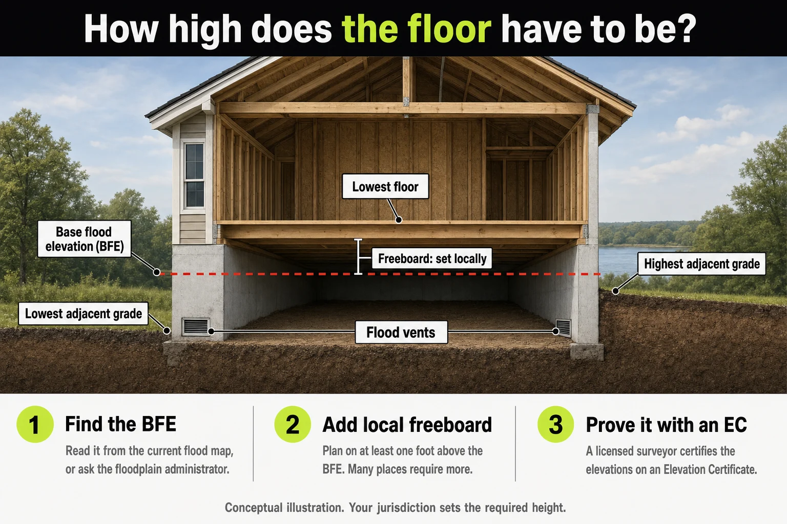
Extra height above the BFE is called freeboard.
Plan on at least one foot above the BFE. That’s FEMA’s recommendation and the national model building code baseline. Many jurisdictions require two feet or more, and the number is set locally, so confirm it with your floodplain administrator before design.
FEMA’s glossary says NFIP standards do not require freeboard, but communities are encouraged to adopt at least one foot. The 2021 International Residential Code, the national model code, sets the lowest floor at BFE plus 1 foot outside Coastal A zones, according to FEMA’s 2021 code fact sheet.
A subdivision plan may set a different number than the floodplain ordinance, so build to the strictest requirement that applies to the lot.
SiteFacts has seen a pad height and an “above BFE” figure in a subdivision plan that turned out to be the developer’s requirement, not the rule for building on the lot. Read the approved subdivision plan and the floodplain ordinance separately.
SiteFacts has seen a Texas lot in Zone AE, a high-risk zone where the BFE is printed on the map, where the existing grade already sat at the BFE, so the lowest floor only had to rise by the local freeboard.
Examples: Oregon, Idaho, Florida, Wisconsin
Local numbers in these examples run from 1 foot to 2 feet. Lane County, Oregon, requires new homes to sit 2 feet above BFE, effective September 7, 2023, and it was 1 foot before that date, per Ordinance 21-07.
Ada County, Idaho, says the lowest floor generally must remain at least one foot above its reference elevation.
Florida’s building code has required BFE plus 1 foot since 2010, according to Florida’s 2018 state floodplain guidance. Wisconsin state rules require the first floor two feet above BFE.
Plain words for your customer: “The house has to sit above the flood line by a set amount, and the local office sets that amount. We’ll confirm it, along with any subdivision rules, before we price the foundation.”
What does Zone A mean when the map shows no BFE?
Zone A is a high-risk zone where FEMA has published no base flood elevation, according to FEMA’s zone legend.
Federal rules tell communities to use any BFE data available from a federal, state or other source. FEMA’s guide to these areas says building there often requires obtaining or calculating a BFE at the site, and that without other data a community may require two or more feet above the highest adjacent grade.
SiteFacts has seen a Texas county require a professional engineer or a surveyor to establish the BFE before it would issue the permit. A blank map there did not mean the lot was clear. It meant nobody had set the number yet.
Examples: Lane County, Oregon
Lane County uses available data first, including FEMA’s Base Level Engineering. Only when none exists does its code fall back to 3 feet above highest adjacent grade, under LC 16.244.
Step 5: Can floor joists or a crawlspace sit below the BFE?
In A zones, FEMA’s EC instructions ask for the elevation at the top of the bottom floor. So a floor system can sit below the BFE in inland A zones if the top of the floor meets the required height and what sits below is built for floodwater.
Anything below the BFE has to be built from flood damage-resistant materials, under 44 CFR 60.3(a)(3). FEMA’s Technical Bulletin 2, updated in 2025, rates materials in its Table 1. I-joists, OSB (oriented strand board) and particle board are all rated Unacceptable below BFE.
So an I-joist and OSB floor system has to sit above the BFE. The same table rates solid standard structural lumber Acceptable, and floor framing Acceptable when it is decay resistant or preservative treated.
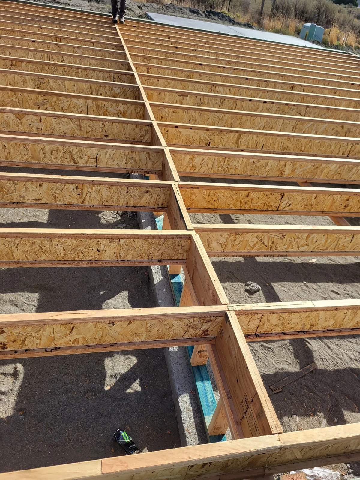
In our experience, anything under the BFE should be pressure treated, which is one more reason to keep floor joists above it. That is SiteFacts practice, not a federal requirement, and local codes may go further.
Enclosed crawlspaces below the BFE need flood openings, which are vents that let floodwater flow in and out. Part 3 covers how many vents you need.
Examples: coastal zones, Lane County
In coastal areas, the building code may measure from the bottom of the lowest horizontal structural member instead. FEMA’s Technical Bulletin 1 notes that the model building codes treat Coastal A zones like V zones where the limit of moderate wave action is mapped or the community designates them.
Lane County’s code recommends elevating the bottom of joists and all insulation above the BFE.
Do utilities have to be above the BFE?
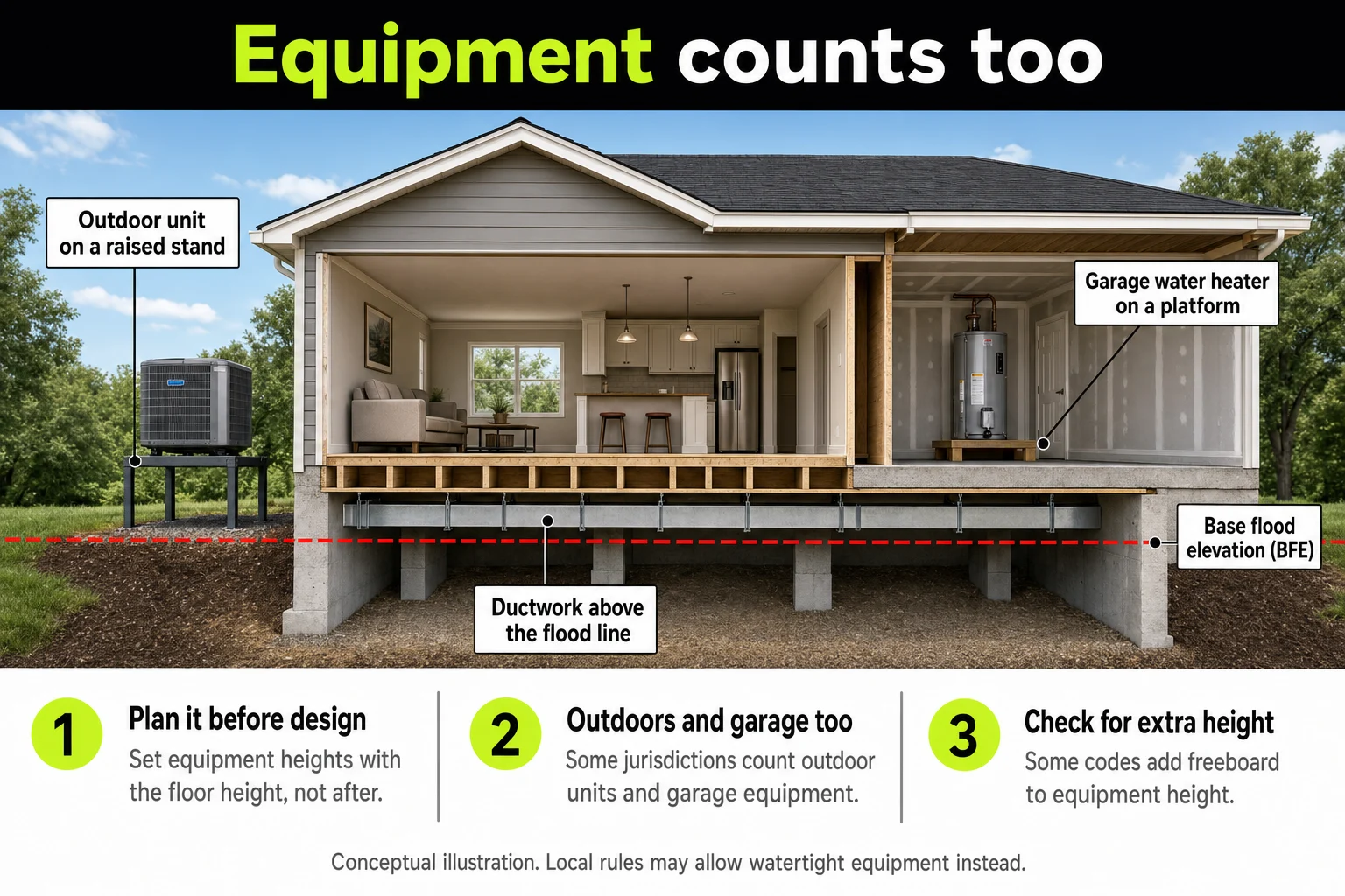
Plan to put mechanical equipment and ductwork above the BFE. The federal rule says electrical, heating, ventilation, plumbing and air conditioning equipment must be designed or located to keep water out. FEMA’s Technical Bulletin 1 lists ductwork, heating and air conditioning equipment, appliances and plumbing fixtures as not allowed below the BFE in an enclosure.
A final certificate is only complete once the furnace, water heater, air conditioner and similar equipment are installed and the grading is done, per the EC’s instructions.
In our experience, some jurisdictions require all equipment, including outdoor units and garage equipment, to be elevated above the BFE or made watertight, and it catches builders who follow their standard process.
Corvallis, Oregon, requires all electrical, mechanical and ductwork in new construction and substantial improvements to be elevated or made watertight to its Design Flood Elevation, under the Corvallis Land Development Code (LDC), section 4.5.110.03.b. LDC 1.6 sets that elevation at one foot above the BFE.
Its nonhabitable attached or detached garages and accessory buildings must have electrical, mechanical and ductwork elevated or flood-proofed at least one foot above the BFE (LDC 4.5.110.06.d).
Plain words for your customer: “The furnace, water heater and outdoor unit may have to sit above the flood line or be sealed against water. We’ll check the local rule and set their heights before we design.”
Can I have a basement in a flood zone?
Generally no. A basement is any area whose floor is below ground on all sides, and a residential basement below the BFE does not meet the lowest floor rule in 44 CFR 60.3(c)(2). The one exception is a narrow one FEMA grants to a few communities for floodproofed basements.
A crawlspace can turn into a basement by accident. FEMA’s bulletin says a crawlspace that is below grade on all sides counts as a basement, including when the footing trenches are not fully backfilled.
Step 6: Can I bring in fill?
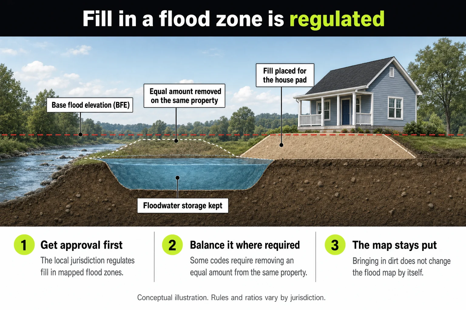
In a mapped flood zone, the local jurisdiction regulates fill, and bringing in dirt does not change the map by itself. In our experience, many jurisdictions have stiff rules on importing fill into flood zones. Permitted fill can lead to a LOMR-F, a Letter of Map Revision based on Fill, covered in the section on getting out of the zone.
Here is a field story. On a 2021 build in western Oregon, balancing the fill, including ballast rock inside the crawlspace, took engineering calculations that added real cost. That is one project’s experience, not a current rule. Part 6 walks through that house.
In our experience, even ballast rock placed inside a crawlspace foundation can count as fill and call for balancing calculations. Ask the administrator how your jurisdiction counts it.
A floodway is the channel and nearby land that must stay clear to carry a flood.
In an adopted floodway, 44 CFR 60.3(d)(3) has communities prohibit encroachments, including fill, unless engineering analysis shows no increase in flood levels.
Examples: Wisconsin and Oregon
In Wisconsin, development in its floodway needs an approved encroachment analysis showing no change in the base flood elevation, or an approved Letter of Map Revision from FEMA, according to Wisconsin DNR.
Corvallis, Oregon, shows the kind of rule you can meet. Its code requires “volumetric exchange” in some floodplain areas, which means an equal amount of material must be removed from the same property for any fill, so the floodplain’s volume is not reduced.
Buildings built with flow-through design, which does not displace floodwater, are exempt.
Ratios vary by place. FEMA’s interim measures for Oregon have cities and counties choose a path that results in no net loss of floodplain storage, and FEMA’s draft model ordinance uses replacement ratios of 1.5 to 1 or 2 to 1 depending on location.
No one ratio is “the Oregon rule.”
Plain words for your customer: “Bringing in dirt doesn’t change the flood map on its own. Some places limit fill, or make us remove the same amount of ground somewhere else. The lot stays mapped until FEMA issues a letter that changes the map.”
Step 7: How do I keep a septic tank from floating?
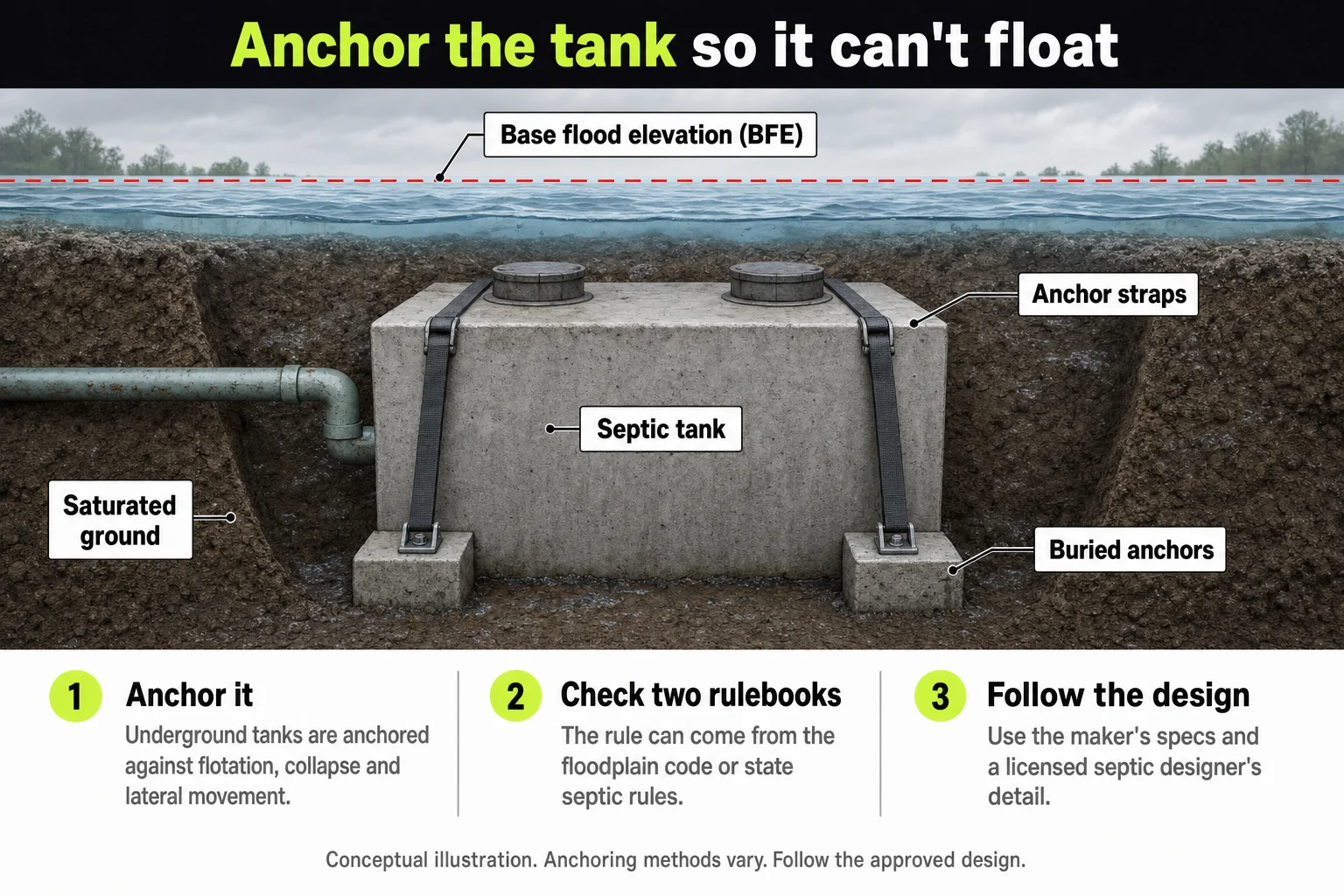
Anchor it. The anchoring rule can come from the local floodplain code or from state septic rules.
Check the tank manufacturer’s installation specs, and ask a licensed septic designer and the local permitting office about the anchoring detail. For an early screening estimate on a lot, there is SepticFacts. A SiteFacts Report does not cover septic feasibility.
Examples: Lane County, Texas, Oregon
In Lane County, LC 16.244 says underground tanks must be anchored to prevent flotation, collapse and lateral movement under base flood conditions.
In Texas, the state’s septic rules say planning materials for a site in a 100-year floodplain “shall indicate how tank flotation is eliminated,” under Title 30 of the Texas Administrative Code, section 285.31(c)(2).
State septic rules can add a separate trigger. Oregon’s Department of Environmental Quality requires tanks in high groundwater areas to be weighted or fitted with an antibuoyancy device. That rule turns on groundwater, not on the flood map.
Step 8: What happens at the end of construction?
You hand the jurisdiction a final, or as-built, elevation certificate. Lane County has the administrator obtain an as-built EC before the final inspection, under LC 16.244.
In our experience, many jurisdictions have a surveyor certify the grade and the finished floor elevation at the end of construction.
Examples: Ada County, Idaho
Ada County says it will not issue a certificate of occupancy until the final elevation certificate is submitted.
Does meeting code keep flood insurance low?
No. The jurisdiction decides whether you can build and how high. The insurer decides what coverage costs.
The two also measure the floor differently. The jurisdiction compares the lowest floor to the BFE. FEMA’s rating looks at first floor height above the adjacent grade.
In our experience, you can do everything a jurisdiction requires and still pay a top level flood insurance premium. Compliance gets the permit. It does not set the price.
Plain words for your customer: “Building to code gets you the permit. It doesn’t set your insurance price. Get a quote from an insurance agent before you commit, and bring the elevation certificate.”
Part 4 covers flood insurance on new construction.
What is the FEMA 50 percent rule?
The FEMA 50 percent rule says that if an improvement costs 50 percent or more of a building’s market value before the work starts, or if restoring damage would cost 50 percent or more of its value before the damage, the building has to meet the rules for new construction. Under 44 CFR 59.1, that damage test is called substantial damage. The federal definition of substantial improvement is any reconstruction, addition or other improvement that costs 50 percent or more of the structure’s market value before the work starts.
FEMA’s materials bulletin says buildings that meet the test must be brought into compliance with the rules for new construction.
Examples: Lane County, Oregon
Some communities add projects up over several years. Lane County counts improvements permitted within the past 5 years.
Can I get my lot out of the flood zone?
Sometimes, through a letter from FEMA. A LOMA, or Letter of Map Amendment, officially removes a lot or building from the high-risk area when the natural ground was already at or above the BFE, because the map was too coarse.
A LOMR-F, or Letter of Map Revision based on Fill, does the same where permitted fill raised the ground. FEMA explains both on its change your flood zone page. A LOMR revises the map itself.
Fill needs local approval, and federal rules limit it in floodways, so a LOMR-F is not a plan for getting around the rules.
A licensed surveyor or engineer certifies the elevations. SiteFacts does not prepare, file or certify a LOMA, LOMR-F or LOMR. A lender can still require flood insurance after one.
Part 5 covers the differences and the process.
What a SiteFacts Report does here, and what it doesn’t
A SiteFacts Report flags the mapped flood zone and the overlays that apply to a lot, and it gives you a jurisdiction call list. Each report is analyst verified and typically delivered in 7 to 10 business days.
It does not survey a lot, prepare an elevation certificate, file a LOMA, make a flood determination, or find flood risk on land that no map covers. A surveyor or engineer does that work, and the floodplain administrator decides what the lot needs.
Know what applies to the lot before you quote
Order a SiteFacts Report on the lot before you quote. The floor height and the permit path remain the floodplain administrator's call.
Terms on this page
- BFE (base flood elevation): the height floodwater reaches in a flood with a 1 percent chance of happening in any year. It is a height, not a depth.
- EC (elevation certificate): FEMA’s form, signed by a licensed surveyor, engineer or architect, that records how high a building sits compared with the BFE.
- FIRM (Flood Insurance Rate Map): the flood map FEMA publishes for a community.
- Floodway: the channel and nearby land that must stay clear to carry the base flood.
- Freeboard: extra height above the BFE used as a safety margin.
- HAG and LAG (highest and lowest adjacent grade): the highest and lowest ground next to the walls of a building.
- LOMA (Letter of Map Amendment): FEMA’s letter removing a lot or building from the high-risk area when the natural ground was already at or above the BFE.
- LOMR (Letter of Map Revision): FEMA’s letter changing the flood map itself.
- LOMR-F (Letter of Map Revision based on Fill): the same kind of removal where permitted fill raised the ground.
- NFIP (National Flood Insurance Program): the federal program that sets floodplain rules for communities and offers flood insurance.
- SFHA (Special Flood Hazard Area): the land FEMA maps as having a 1 percent chance of flooding in any year.
- Substantial damage: damage of any origin where restoring the building to its condition before the damage would cost 50 percent or more of its market value before the damage.
- Substantial improvement: work that costs 50 percent or more of a structure’s market value before the work starts.