LOMA vs LOMR-F: How to Get a Lot Out of the Flood Zone
LOMA, LOMR-F and LOMR are three different FEMA letters. Here is which one fits a lot, who does the work, and what fill has to do with it.
Last reviewed: 2026-11-05. Flood rules change and vary by jurisdiction. Confirm with your local floodplain administrator.
Your customer brings you a lot in a flood zone and asks whether it can be taken out of the zone. Sometimes it can, through a letter from the Federal Emergency Management Agency (FEMA), and which letter depends on how the ground got to its height.
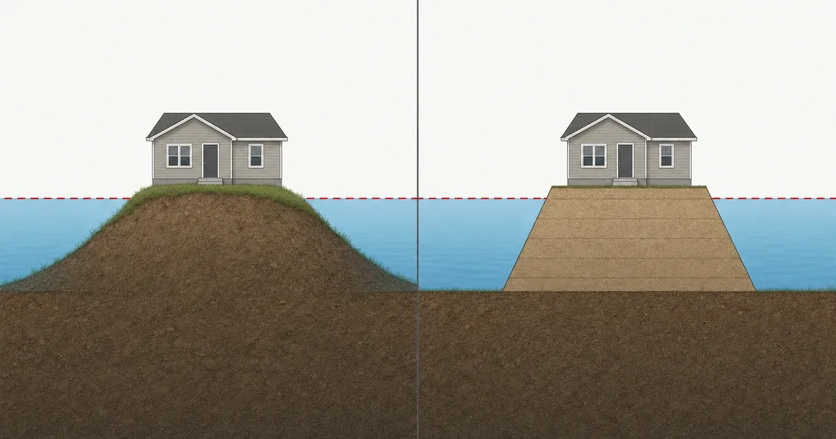
A LOMA (Letter of Map Amendment) is FEMA’s letter removing a lot or building from the high-risk flood area because the natural ground was already at or above the base flood elevation. A LOMR-F (Letter of Map Revision based on Fill) does the same where permitted fill raised the ground. A LOMR (Letter of Map Revision) redraws the map itself.
The base flood elevation, or BFE, is the height floodwater reaches in a flood with a 1 percent chance of happening in any year, according to FEMA’s glossary. The high-risk area FEMA maps around that flood is the Special Flood Hazard Area, or SFHA.
These letters record how the ground sits. They are not a shortcut around the flood rules.
Table of contents
- What is a LOMA?
- What is a LOMR-F, and why is fill not a shortcut?
- What is a LOMR, and why do maps change anyway?
- How do I get a lot out of a flood zone, and what does it cost?
- Does a LOMA end flood insurance?
- Who does the work?
- What a SiteFacts Report does here
- Terms on this page
What is a LOMA?
A LOMA is FEMA’s letter saying a lot or building sits on naturally high ground, not ground raised by fill, and would not be flooded by the base flood. FEMA’s change your flood zone page describes it that way.
The test is elevation. For a building, the lowest ground touching it must be at or above the BFE. For a lot, the lowest point on the lot must be at or above the BFE, under FEMA’s LOMA and LOMR-F page.
FEMA runs the two tests separately. A letter that is granted officially removes the property or building from the SFHA.
In our experience, this is the case where the flood map was too coarse to show the high ground. If part of the lot sits below the BFE, the lot as a whole does not pass the test.
Plain words for your customer: “A LOMA is for ground that was always high. A surveyor measures it, and FEMA decides. If your lot sits low, we plan the house around the flood rules instead.”
What is a LOMR-F, and why is fill not a shortcut?
A LOMR-F is FEMA’s letter for a lot or building that fill has raised above the BFE. FEMA describes it for property that has been elevated by earthen fill and would not be flooded by the base flood. The fill comes first, and the LOMR-F comes second.
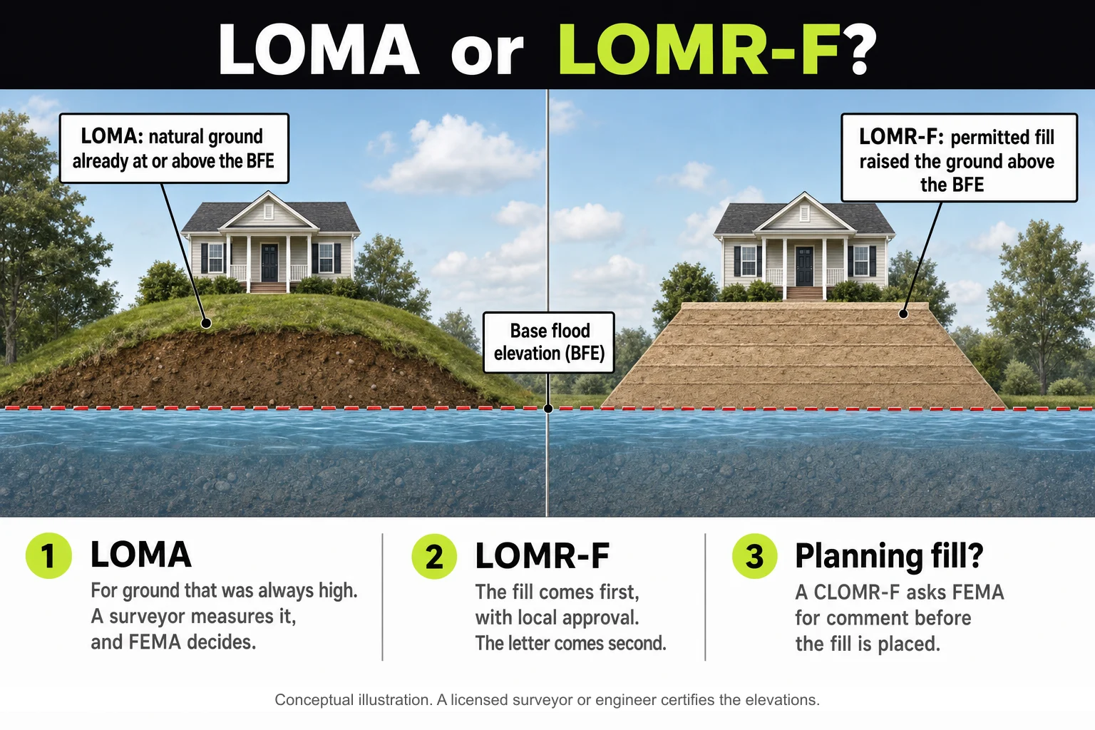
Before placing fill, a builder can ask FEMA for comment with a CLOMR-F, a Conditional Letter of Map Revision based on Fill, which the Code of Federal Regulations (CFR) lists with the other letters, in 44 CFR 72.4(g).
Placing the fill is its own approval, and it is where most of the trouble sits. In our experience, many jurisdictions have stiff rules on importing fill into flood zones, so bringing in dirt is not a plan for getting a lot out of the zone.
The rules start at the federal level. In an adopted floodway, which is the channel and nearby land that must stay clear to carry a flood, federal floodplain rules have communities prohibit fill unless engineering analysis shows no increase in flood levels, under 44 CFR 60.3(d)(3).
Wisconsin shows how a state applies it. Development in a Wisconsin floodway needs an approved encroachment analysis showing no change in the BFE, or an approved Letter of Map Revision from FEMA, according to Wisconsin DNR.
Local permits come next. In Garden City, Idaho, grading or placing fill in the floodplain takes the City’s full floodplain and floodway application.
Some codes also make you take material back out. Corvallis, Oregon, requires “volumetric exchange” in some floodplain areas, which means an equal amount of material must be removed from the same property for any fill, so the floodplain’s volume is not reduced, under the Corvallis land development code.
Part 1 covers the rest in Step 6, bringing in fill.
Plain words for your customer: “Bringing in dirt doesn’t change the map on its own. The city has to approve the fill first. Once it’s placed and a surveyor certifies the new ground, we can ask FEMA for a letter.”
What is a LOMR, and why do maps change anyway?
A LOMR is FEMA’s letter officially revising the current map to show changes to floodplains, floodways or flood elevations. FEMA’s LOMR and CLOMR page says a community or an individual can request one. In our experience, a LOMR is usually a bigger engineering job than a LOMA.
A CLOMR, or Conditional Letter of Map Revision, comes before construction. It is FEMA’s comment on whether a proposed project would meet minimum National Flood Insurance Program (NFIP) standards, according to the same page.
For a LOMR or CLOMR request, 44 CFR 72.4(h) gives FEMA 60 days to say whether the request is adequate and 90 days to respond once it has adequate information and the fee.
Maps also change without anyone filing a letter. FEMA’s Map Service Center warns that what you download or print may be superseded by new maps over time. When new FEMA flood maps are adopted, FloodSmart’s flood zone page says insurance requirements and the cost of a policy may change.
On Oregon’s McKenzie River, FEMA’s pending flood map update was issued as preliminary maps in early 2020, the September 2020 Holiday Farm Fire changed the watershed, and the preliminary data has been reissued since. A map you pulled for one purchase may not be the one that governs your permit.
So pull the current effective map panel when the customer brings you the lot, and again before design and before you apply for the permit. Ask the floodplain administrator whether a map update, a LOMR or a local study is pending. Part 1 walks through it in Step 1, the current flood map.
How do I get a lot out of a flood zone, and what does it cost?
For a LOMA, FEMA charges no review fee. For a LOMR-F, FEMA charges one. Federal rule 44 CFR 72.5(c) exempts LOMA requests from review and processing fees, while 44 CFR 72.3(c)(1) sets flat user fees for LOMR-F requests on single lots or structures.
Check FEMA’s current fee schedule before you quote a number to a customer, because the amount is not in the rule.
The surveyor or engineer who certifies the elevations is a separate cost. Get quotes before you tell the customer what the whole path costs.
The path runs in this order. Pull the current map panel and the BFE for the lot. Have a licensed surveyor or engineer measure and certify the ground.
File the request with FEMA, which takes applications through its online application system, according to the change your flood zone page. FEMA names the MT-EZ form for a LOMA on a single residential lot or building and the MT-1 form for multiple lots and for all LOMR-F requests, per its LOMA and LOMR-F page.
The FEMA clock starts late, and it differs by letter. For LOMA and LOMR-F requests, and their conditional versions, 44 CFR 72.4(g) has FEMA notify the requester and the community within 30 days whether the submittal is adequate. FEMA then responds within 60 days of receiving adequate information and the fee.
The 60 days start when FEMA has complete data, not when you first submit. LOMR requests run on the 60 and 90 day clock described above.
Your community may want to see a LOMR-F request first. In Lafayette, Louisiana, the local floodplain office reviews the completed LOMR-F application, and a community official signs a Community Acknowledgement Form that is required before the application goes to FEMA. The floodplain administrator has a 15 business day initial review time, according to Lafayette Consolidated Government’s page.
Other communities may work differently, so confirm this with your floodplain administrator, along with which local rules still apply to the lot after a letter is issued.
Does a LOMA end flood insurance?
A LOMA or LOMR-F ends the federal requirement to buy flood insurance, but it does not stop a lender from requiring it. FEMA’s LOMA and LOMR-F page says the mortgage lender keeps the right to require flood insurance.
A LOMR changes the map itself, so ask the lender how a map revision affects the requirement on a specific lot. Confirm this before you tell a customer.
What the quote will look like afterward is a separate question for an insurance agent, so do not promise a customer a savings. Part 4 covers why code doesn’t set the premium.
Plain words for your customer: “A letter from FEMA can end the federal requirement. Your lender can still ask for flood insurance, so ask them before you count on dropping it.”
Who does the work?
A licensed surveyor or an engineer does the work, not SiteFacts. SiteFacts does not prepare, file or certify a LOMA, LOMR-F or LOMR request.
FEMA’s LOMA and LOMR-F page asks for elevation information certified by a licensed land surveyor or registered professional engineer, to the nearest tenth of a foot, on the NFIP map datum.
The instructions for the elevation certificate (EC), FEMA’s form that records how high a building sits compared with the BFE, add that an architect can certify where state law authorizes it, per FEMA’s EC instructions. Ask the professional which one your state allows.
Licensed professionals can also file LOMA requests through eLOMA, an online route FEMA offers them, according to the change your flood zone page.
What a SiteFacts Report does here, and what it doesn’t
A SiteFacts Report flags the mapped flood zone and the overlays that apply to a lot, and it gives you a jurisdiction call list. Each report is analyst verified and typically delivered in 7 to 10 business days.
It does not measure the ground, so it cannot say whether a lot qualifies for a LOMA. It does not prepare an elevation certificate, file a LOMA, LOMR-F or LOMR, or make a flood determination. A surveyor or engineer does that work, and the floodplain administrator decides what the lot needs.
Know what applies to the lot before you quote
Order a SiteFacts Report on the lot before you quote. The map change path and the permit path remain the floodplain administrator's and FEMA's call.
Terms on this page
- BFE (base flood elevation): the height floodwater reaches in a flood with a 1 percent chance of happening in any year. It is a height, not a depth.
- CLOMR (Conditional Letter of Map Revision): FEMA’s comment on whether a proposed project would meet minimum National Flood Insurance Program standards.
- EC (elevation certificate): FEMA’s form that records how high a building sits compared with the BFE.
- Floodway: the channel and nearby land that must stay clear to carry the base flood.
- LOMA (Letter of Map Amendment): FEMA’s letter removing a lot or building from the high-risk area when the natural ground was already at or above the BFE.
- LOMR (Letter of Map Revision): FEMA’s letter changing the flood map itself.
- LOMR-F (Letter of Map Revision based on Fill): the same kind of removal where permitted fill raised the ground.
- NFIP (National Flood Insurance Program): the federal program that sets floodplain rules for communities and offers flood insurance.
- SFHA (Special Flood Hazard Area): the land FEMA maps as having a 1 percent chance of flooding in any year.