
The SiteFacts Builder's Guide to Building in a Flood Zone
Seven parts and a printable checklist for builders, sales teams and site leads
Last reviewed: 2026-11-05
Flood rules change and vary by jurisdiction. Confirm with your local floodplain administrator.
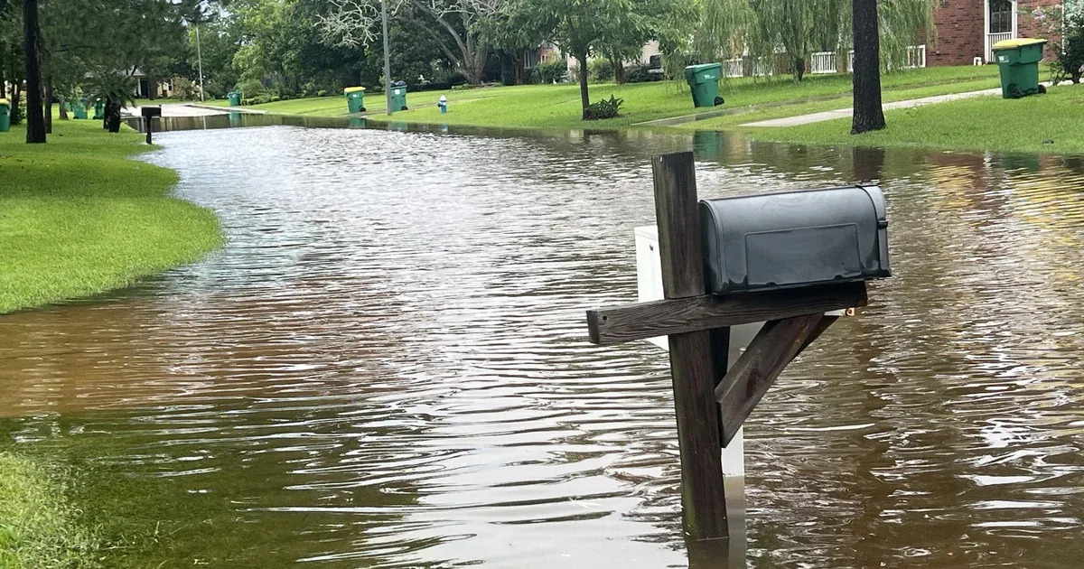
In the print dialog, choose Save as PDF. Turn on Background graphics if the boxes print without color.
Part 1: Your Customer's Lot Is in a Flood Zone. Can You Build? A Builder's Step-by-Step Guide
Last reviewed: 2026-11-05. Flood rules change and vary by jurisdiction. Confirm with your local floodplain administrator.
A customer brings you a lot and a floor plan. The listing never mentioned a flood zone, or the customer saw the map and figured it was a small problem. Now you have to work out whether you can build, and how, before you quote a price.
Building in a mapped flood zone, also called a floodplain, is usually possible. First you need a floodplain development permit from the local jurisdiction.
The federal rule, 44 CFR 60.3 in the Code of Federal Regulations (CFR), makes participating communities require one in mapped A zones. The house also has to sit at or above a set height.
Plan on a surveyor, an elevation certificate, flood vents or an elevated floor system, and careful fill planning.
Table of contents
- What does it take to build in a flood zone?
- Is it worth building in a floodplain?
- Step 0: Is the lot in a flood zone, and does the customer know?
- Step 1: Which flood map is current for my lot?
- Step 2: What is a floodplain development permit?
- Step 3: Do I need a surveyor?
- Step 4: How high does the floor need to be above the base flood elevation?
- What does Zone A mean when the map shows no BFE?
- Step 5: Can floor joists or a crawlspace sit below the BFE?
- Do utilities have to be above the BFE?
- Can I have a basement in a flood zone?
- Step 6: Can I bring in fill?
- Step 7: How do I keep a septic tank from floating?
- Step 8: What happens at the end of construction?
- Does meeting code keep flood insurance low?
- What is the FEMA 50 percent rule?
- Can I get my lot out of the flood zone?
- What a SiteFacts Report does here
- Terms on this page
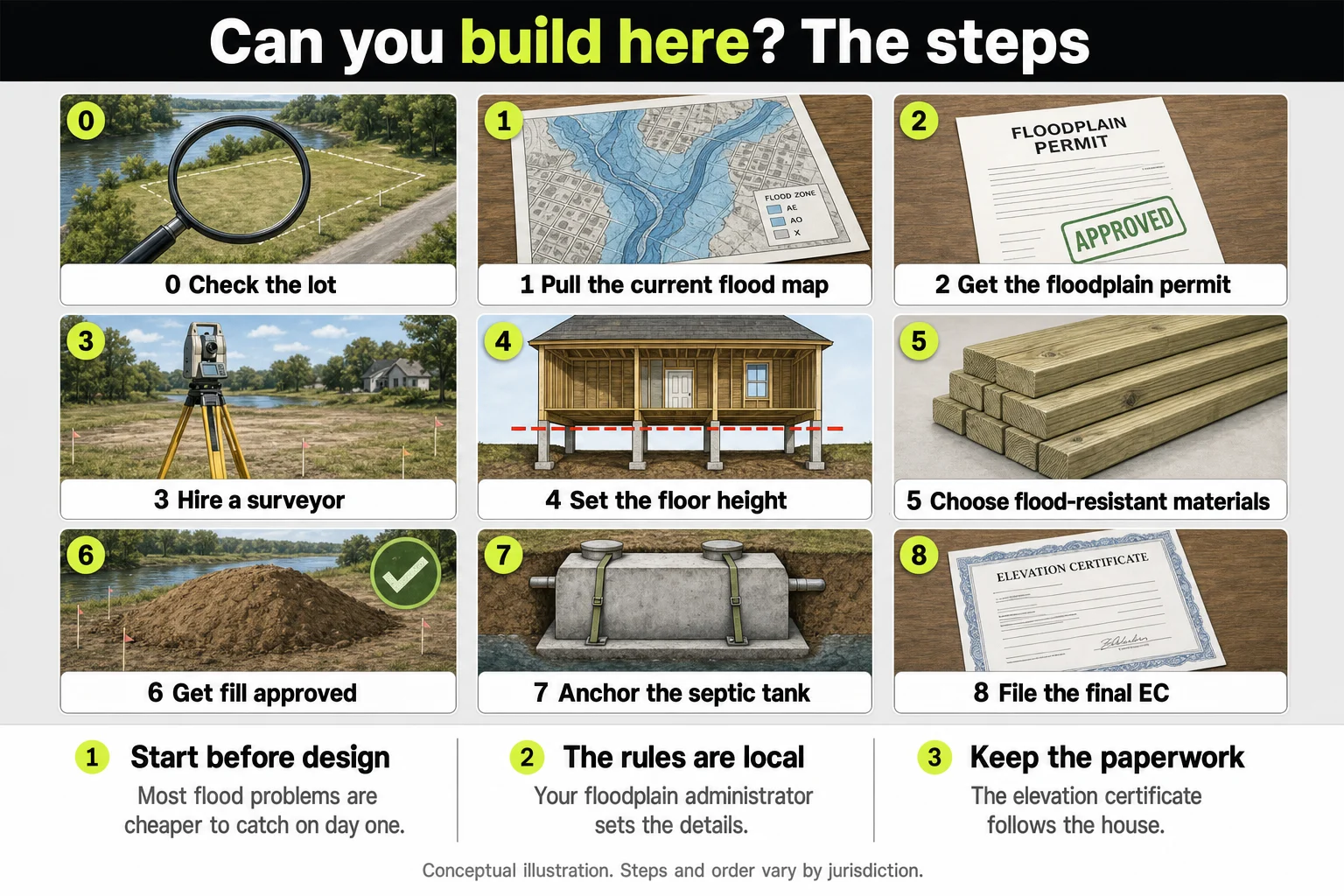
| Step | What closes it | Who to call |
|---|---|---|
| Step 0: Lot check | Address checked on the Flood Map Service Center of the Federal Emergency Management Agency (FEMA), floodplain office called | Local floodplain office |
| Step 1: Flood map | Current effective FIRM (Flood Insurance Rate Map) panel, with panel number and date | FEMA’s Flood Map Service Center, then the floodplain administrator |
| Step 2: Permit | Floodplain development permit | Floodplain administrator |
| Step 3: Surveyor | Base flood elevation (BFE) stake, and the elevation certificate (EC) at the stage the jurisdiction requires | Licensed surveyor |
| Step 4: Floor height | Freeboard number, which is the extra height above the BFE | Floodplain administrator |
| Step 5: Materials | Confirmed that materials below the BFE, flood openings and equipment location meet the local rules | Floodplain administrator |
| Step 6: Fill | Local approval for any fill | Floodplain administrator |
| Step 7: Septic | Tank anchoring detail | Licensed septic designer and the local permitting office |
| Step 8: Final | Final (as-built) EC | Licensed surveyor and the floodplain administrator |
In this series:
- Part 1, this guide.
- Part 2: Elevation Certificates, on timing, cost and what gets measured.
- Part 3: Flood Vents, on requirements and how many you need.
- Part 4: Flood Insurance, on why meeting code does not set your premium.
- Part 5: LOMA vs LOMR-F, on getting a lot out of the flood zone.
- Part 6: How to Build a House in a Flood Zone, on design decisions in order, from floor height to stairs.
- Part 7: Floodplain Development Permit, on what the permit covers, what goes in the application and how review works.
What does it take to build in a flood zone?
Eight steps, in the order a builder works them out: check the map, get the local permit, hire a surveyor, set the floor height, choose materials, plan any fill, protect the septic tank, and close out with a final certificate.
FEMA, the Federal Emergency Management Agency, sets the federal minimums for communities in the National Flood Insurance Program, or NFIP. Your city or county adopts them, can make them stricter, and issues the permit. Under 44 CFR 60.1(d), a section of the Code of Federal Regulations, a state or local rule that is more restrictive takes precedence over the federal criteria.
Your floodplain administrator, the local official who runs the program, has the final word.
Part 6 shows how these pieces fit together on one house, in the order the decisions get made: how to build a house in a flood zone.
Is it worth building in a floodplain?
It can be, when the lot is priced for the extra work. In a mapped flood zone, that work is the local permit, surveyor visits and elevation certificates, the required floor height, limits on fill, and a flood insurance quote that meeting code does not set.
Know each of those before your customer commits to the lot, so your quote reflects the work.
Take the steps below in order. The SiteFacts Report section shows what a Report covers on the lot and what it leaves to a surveyor and the floodplain administrator.
Step 0: Is the lot in a flood zone, and does the customer know?
Check before the first design conversation. Search the lot’s address on FEMA’s Flood Map Service Center and call the local floodplain office.
The high-risk kind of flood zone is called the Special Flood Hazard Area, or SFHA. It is the land FEMA maps as having a 1 percent chance of flooding in any given year.
The base flood elevation, or BFE, is the height floodwater reaches in a flood with a 1 percent chance of happening in any year, according to FEMA’s glossary.
Three ideas come up often.
- The listing said there is no flood zone.
- Fill will fix it.
- Insurance will be normal if the house is built to code.
Step 1 shows whether the lot is mapped and whether the listing’s map information is current. Step 6 answers the second, and the insurance section the third.
Step 1: Which flood map is current for my lot?
Pull the current effective FIRM panel for the lot, and write down the panel number and its effective date. The FIRM, or Flood Insurance Rate Map, is the map FEMA publishes for each community. A zone letter alone is not enough.
Maps change. FEMA’s own site warns that what you download or print may be superseded by new maps over time.
So pull the panel when the customer brings you the lot, and again before design and before you apply for the permit. Ask the floodplain administrator whether a map update, a Letter of Map Revision (LOMR, which changes the map itself), or a local study is pending. For what each zone letter means, see our post on flood zones before you buy.
Examples: Oregon map history
In Lane County, Oregon, the floodplain code, as amended in 2021, adopts FIRM panels in one ordinance, and those panels carry effective dates of both 1999 and 2020, according to Ordinance 21-07.
On Oregon’s McKenzie River, FEMA’s pending flood map update was issued as preliminary maps in early 2020, the September 2020 Holiday Farm Fire changed the watershed, and the preliminary data has been reissued since. A map you pulled for one purchase may not be the one that governs your permit.
Plain words for your customer: “The map tells us the zone. It doesn’t tell us how high your lot sits, and it can change between now and your permit. We’ll pull the current map today and again before we design.”
Step 2: What is a floodplain development permit?
It is a local permit that sets how you can develop in the floodplain. In our experience, the process ranges widely, from a simple planning review to a full conditional use permit. It comes first because it governs everything after it.
Part 7 covers what the permit covers and how to get one.
Under 44 CFR 60.3(b)(1) and (c)(1), participating communities must require permits for all proposed construction and other development in mapped A zones, with or without a published BFE. That covers Zone A, AE, A1-30, AH and AO. How the permit works is up to the community.
Examples: Idaho and Lane County
Idaho shows the range. In Garden City, work that is exempt and outside the floodway needs only a Minor Work Floodplain Permit with an application form.
A floodway is the channel and nearby land that has to stay clear to carry a flood. Grading or placing fill in the floodplain, or work in the floodway, takes the full floodplain and floodway application.
Ada County, Idaho, adds a sequencing rule. You may apply for a building permit at the same time, but Ada County’s page says the building permit will not be issued until the County Engineer approves the floodplain permit.
Lane County shows the range inside one code. Its ordinance requires a development permit before construction in the high-risk area, including for fill, and says new homes must be located outside the SFHA unless the applicant shows that is infeasible.
Some of those cases go through a Type I review, and cases that need judgment go through a discretionary Type II review. That is in Ordinance 21-07, and it covers unincorporated Lane County only.
Step 3: Do I need a surveyor?
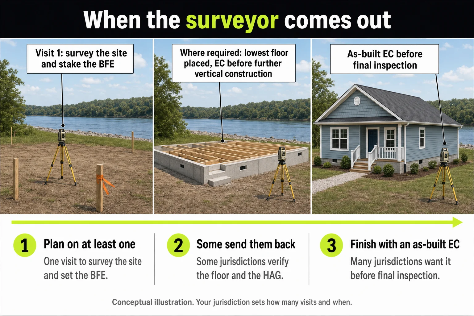
Yes. A licensed surveyor provides the elevation certificate, or EC, the FEMA form that records how high a building sits compared with the base flood elevation. Where state law allows, an engineer or architect can sign it, according to FEMA’s EC instructions.
SiteFacts’ advice is to have the surveyor stake the base flood elevation on site, so you and your customer can see what you are working with.
In our experience, plan on at least one surveyor visit to survey the site and set the BFE. Some jurisdictions also send the surveyor back to verify the finished floor and the highest adjacent grade, or HAG. HAG is the highest ground next to the walls of the house.
The number and timing of visits depend on the jurisdiction. Part 2 covers timing and cost.
Step 4: How high does the floor need to be above the base flood elevation?
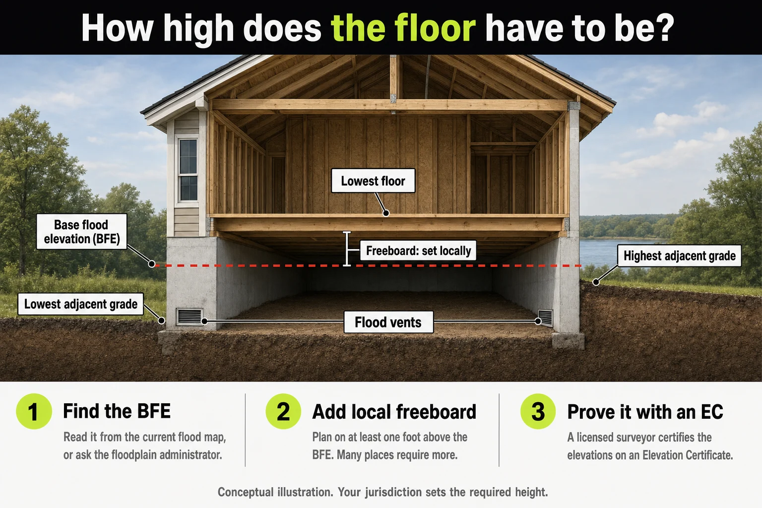
Extra height above the BFE is called freeboard.
Plan on at least one foot above the BFE. That’s FEMA’s recommendation and the national model building code baseline. Many jurisdictions require two feet or more, and the number is set locally, so confirm it with your floodplain administrator before design.
FEMA’s glossary says NFIP standards do not require freeboard, but communities are encouraged to adopt at least one foot. The 2021 International Residential Code, the national model code, sets the lowest floor at BFE plus 1 foot outside Coastal A zones, according to FEMA’s 2021 code fact sheet.
A subdivision plan may set a different number than the floodplain ordinance, so build to the strictest requirement that applies to the lot.
SiteFacts has seen a pad height and an “above BFE” figure in a subdivision plan that turned out to be the developer’s requirement, not the rule for building on the lot. Read the approved subdivision plan and the floodplain ordinance separately.
SiteFacts has seen a Texas lot in Zone AE, a high-risk zone where the BFE is printed on the map, where the existing grade already sat at the BFE, so the lowest floor only had to rise by the local freeboard.
Examples: Oregon, Idaho, Florida, Wisconsin
Local numbers in these examples run from 1 foot to 2 feet. Lane County, Oregon, requires new homes to sit 2 feet above BFE, effective September 7, 2023, and it was 1 foot before that date, per Ordinance 21-07.
Ada County, Idaho, says the lowest floor generally must remain at least one foot above its reference elevation.
Florida’s building code has required BFE plus 1 foot since 2010, according to Florida’s 2018 state floodplain guidance. Wisconsin state rules require the first floor two feet above BFE.
Plain words for your customer: “The house has to sit above the flood line by a set amount, and the local office sets that amount. We’ll confirm it, along with any subdivision rules, before we price the foundation.”
What does Zone A mean when the map shows no BFE?
Zone A is a high-risk zone where FEMA has published no base flood elevation, according to FEMA’s zone legend.
Federal rules tell communities to use any BFE data available from a federal, state or other source. FEMA’s guide to these areas says building there often requires obtaining or calculating a BFE at the site, and that without other data a community may require two or more feet above the highest adjacent grade.
SiteFacts has seen a Texas county require a professional engineer or a surveyor to establish the BFE before it would issue the permit. A blank map there did not mean the lot was clear. It meant nobody had set the number yet.
Examples: Lane County, Oregon
Lane County uses available data first, including FEMA’s Base Level Engineering. Only when none exists does its code fall back to 3 feet above highest adjacent grade, under LC 16.244.
Step 5: Can floor joists or a crawlspace sit below the BFE?
In A zones, FEMA’s EC instructions ask for the elevation at the top of the bottom floor. So a floor system can sit below the BFE in inland A zones if the top of the floor meets the required height and what sits below is built for floodwater.
Anything below the BFE has to be built from flood damage-resistant materials, under 44 CFR 60.3(a)(3). FEMA’s Technical Bulletin 2, updated in 2025, rates materials in its Table 1. I-joists, OSB (oriented strand board) and particle board are all rated Unacceptable below BFE.
So an I-joist and OSB floor system has to sit above the BFE. The same table rates solid standard structural lumber Acceptable, and floor framing Acceptable when it is decay resistant or preservative treated.
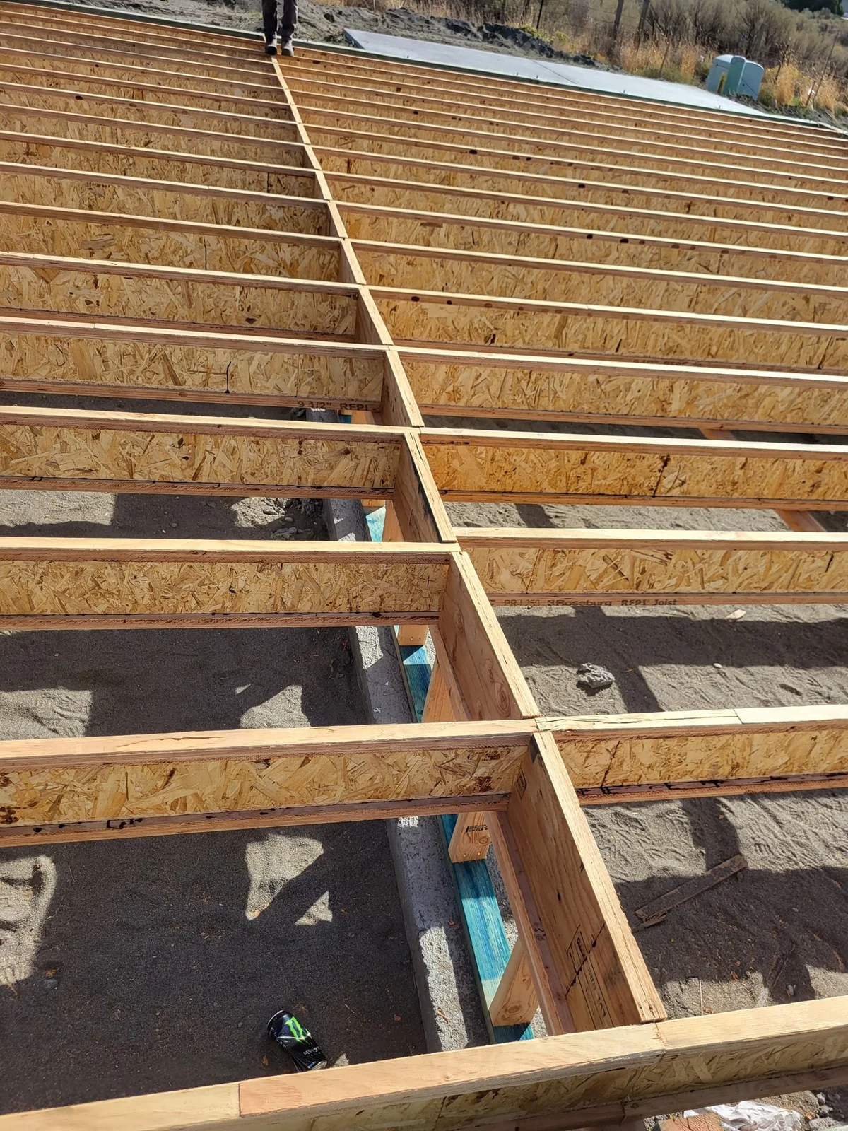
In our experience, anything under the BFE should be pressure treated, which is one more reason to keep floor joists above it. That is SiteFacts practice, not a federal requirement, and local codes may go further.
Enclosed crawlspaces below the BFE need flood openings, which are vents that let floodwater flow in and out. Part 3 covers how many vents you need.
Examples: coastal zones, Lane County
In coastal areas, the building code may measure from the bottom of the lowest horizontal structural member instead. FEMA’s Technical Bulletin 1 notes that the model building codes treat Coastal A zones like V zones where the limit of moderate wave action is mapped or the community designates them.
Lane County’s code recommends elevating the bottom of joists and all insulation above the BFE.
Do utilities have to be above the BFE?
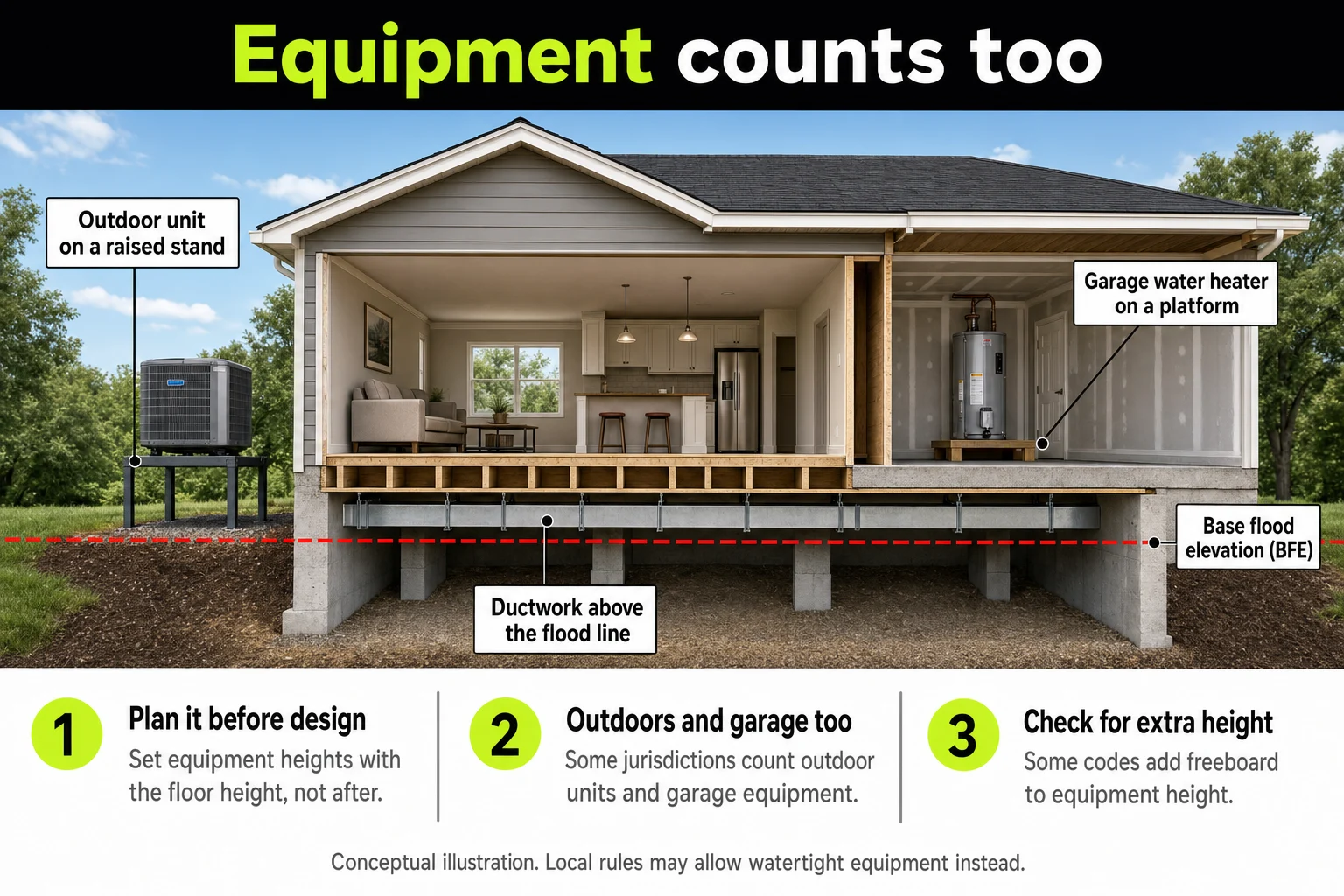
Plan to put mechanical equipment and ductwork above the BFE. The federal rule says electrical, heating, ventilation, plumbing and air conditioning equipment must be designed or located to keep water out. FEMA’s Technical Bulletin 1 lists ductwork, heating and air conditioning equipment, appliances and plumbing fixtures as not allowed below the BFE in an enclosure.
A final certificate is only complete once the furnace, water heater, air conditioner and similar equipment are installed and the grading is done, per the EC’s instructions.
In our experience, some jurisdictions require all equipment, including outdoor units and garage equipment, to be elevated above the BFE or made watertight, and it catches builders who follow their standard process.
Corvallis, Oregon, requires all electrical, mechanical and ductwork in new construction and substantial improvements to be elevated or made watertight to its Design Flood Elevation, under the Corvallis Land Development Code (LDC), section 4.5.110.03.b. LDC 1.6 sets that elevation at one foot above the BFE.
Its nonhabitable attached or detached garages and accessory buildings must have electrical, mechanical and ductwork elevated or flood-proofed at least one foot above the BFE (LDC 4.5.110.06.d).
Plain words for your customer: “The furnace, water heater and outdoor unit may have to sit above the flood line or be sealed against water. We’ll check the local rule and set their heights before we design.”
Can I have a basement in a flood zone?
Generally no. A basement is any area whose floor is below ground on all sides, and a residential basement below the BFE does not meet the lowest floor rule in 44 CFR 60.3(c)(2). The one exception is a narrow one FEMA grants to a few communities for floodproofed basements.
A crawlspace can turn into a basement by accident. FEMA’s bulletin says a crawlspace that is below grade on all sides counts as a basement, including when the footing trenches are not fully backfilled.
Step 6: Can I bring in fill?
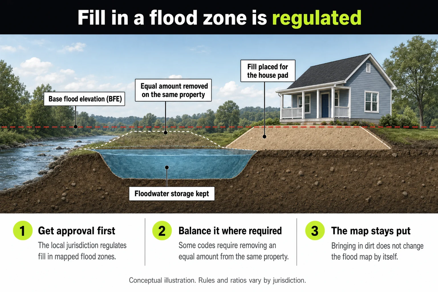
In a mapped flood zone, the local jurisdiction regulates fill, and bringing in dirt does not change the map by itself. In our experience, many jurisdictions have stiff rules on importing fill into flood zones. Permitted fill can lead to a LOMR-F, a Letter of Map Revision based on Fill, covered in the section on getting out of the zone.
Here is a field story. On a 2021 build in western Oregon, balancing the fill, including ballast rock inside the crawlspace, took engineering calculations that added real cost. That is one project’s experience, not a current rule. Part 6 walks through that house.
In our experience, even ballast rock placed inside a crawlspace foundation can count as fill and call for balancing calculations. Ask the administrator how your jurisdiction counts it.
A floodway is the channel and nearby land that must stay clear to carry a flood.
In an adopted floodway, 44 CFR 60.3(d)(3) has communities prohibit encroachments, including fill, unless engineering analysis shows no increase in flood levels.
Examples: Wisconsin and Oregon
In Wisconsin, development in its floodway needs an approved encroachment analysis showing no change in the base flood elevation, or an approved Letter of Map Revision from FEMA, according to Wisconsin DNR.
Corvallis, Oregon, shows the kind of rule you can meet. Its code requires “volumetric exchange” in some floodplain areas, which means an equal amount of material must be removed from the same property for any fill, so the floodplain’s volume is not reduced.
Buildings built with flow-through design, which does not displace floodwater, are exempt.
Ratios vary by place. FEMA’s interim measures for Oregon have cities and counties choose a path that results in no net loss of floodplain storage, and FEMA’s draft model ordinance uses replacement ratios of 1.5 to 1 or 2 to 1 depending on location.
No one ratio is “the Oregon rule.”
Plain words for your customer: “Bringing in dirt doesn’t change the flood map on its own. Some places limit fill, or make us remove the same amount of ground somewhere else. The lot stays mapped until FEMA issues a letter that changes the map.”
Step 7: How do I keep a septic tank from floating?
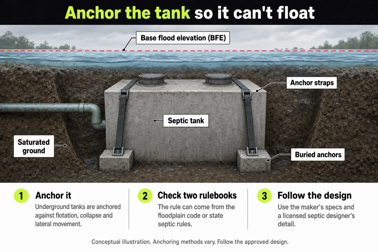
Anchor it. The anchoring rule can come from the local floodplain code or from state septic rules.
Check the tank manufacturer’s installation specs, and ask a licensed septic designer and the local permitting office about the anchoring detail. For an early screening estimate on a lot, there is SepticFacts. A SiteFacts Report does not cover septic feasibility.
Examples: Lane County, Texas, Oregon
In Lane County, LC 16.244 says underground tanks must be anchored to prevent flotation, collapse and lateral movement under base flood conditions.
In Texas, the state’s septic rules say planning materials for a site in a 100-year floodplain “shall indicate how tank flotation is eliminated,” under Title 30 of the Texas Administrative Code, section 285.31(c)(2).
State septic rules can add a separate trigger. Oregon’s Department of Environmental Quality requires tanks in high groundwater areas to be weighted or fitted with an antibuoyancy device. That rule turns on groundwater, not on the flood map.
Step 8: What happens at the end of construction?
You hand the jurisdiction a final, or as-built, elevation certificate. Lane County has the administrator obtain an as-built EC before the final inspection, under LC 16.244.
In our experience, many jurisdictions have a surveyor certify the grade and the finished floor elevation at the end of construction.
Examples: Ada County, Idaho
Ada County says it will not issue a certificate of occupancy until the final elevation certificate is submitted.
Does meeting code keep flood insurance low?
No. The jurisdiction decides whether you can build and how high. The insurer decides what coverage costs.
The two also measure the floor differently. The jurisdiction compares the lowest floor to the BFE. FEMA’s rating looks at first floor height above the adjacent grade.
In our experience, you can do everything a jurisdiction requires and still pay a top level flood insurance premium. Compliance gets the permit. It does not set the price.
Plain words for your customer: “Building to code gets you the permit. It doesn’t set your insurance price. Get a quote from an insurance agent before you commit, and bring the elevation certificate.”
Part 4 covers flood insurance on new construction.
What is the FEMA 50 percent rule?
The FEMA 50 percent rule says that if an improvement costs 50 percent or more of a building’s market value before the work starts, or if restoring damage would cost 50 percent or more of its value before the damage, the building has to meet the rules for new construction. Under 44 CFR 59.1, that damage test is called substantial damage. The federal definition of substantial improvement is any reconstruction, addition or other improvement that costs 50 percent or more of the structure’s market value before the work starts.
FEMA’s materials bulletin says buildings that meet the test must be brought into compliance with the rules for new construction.
Examples: Lane County, Oregon
Some communities add projects up over several years. Lane County counts improvements permitted within the past 5 years.
Can I get my lot out of the flood zone?
Sometimes, through a letter from FEMA. A LOMA, or Letter of Map Amendment, officially removes a lot or building from the high-risk area when the natural ground was already at or above the BFE, because the map was too coarse.
A LOMR-F, or Letter of Map Revision based on Fill, does the same where permitted fill raised the ground. FEMA explains both on its change your flood zone page. A LOMR revises the map itself.
Fill needs local approval, and federal rules limit it in floodways, so a LOMR-F is not a plan for getting around the rules.
A licensed surveyor or engineer certifies the elevations. SiteFacts does not prepare, file or certify a LOMA, LOMR-F or LOMR. A lender can still require flood insurance after one.
Part 5 covers the differences and the process.
What a SiteFacts Report does here, and what it doesn’t
A SiteFacts Report flags the mapped flood zone and the overlays that apply to a lot, and it gives you a jurisdiction call list. Each report is analyst verified and typically delivered in 7 to 10 business days.
It does not survey a lot, prepare an elevation certificate, file a LOMA, make a flood determination, or find flood risk on land that no map covers. A surveyor or engineer does that work, and the floodplain administrator decides what the lot needs.
Know what applies to the lot before you quote
Order a SiteFacts Report on the lot before you quote. The floor height and the permit path remain the floodplain administrator's call.
Terms on this page
- BFE (base flood elevation): the height floodwater reaches in a flood with a 1 percent chance of happening in any year. It is a height, not a depth.
- EC (elevation certificate): FEMA’s form, signed by a licensed surveyor, engineer or architect, that records how high a building sits compared with the BFE.
- FIRM (Flood Insurance Rate Map): the flood map FEMA publishes for a community.
- Floodway: the channel and nearby land that must stay clear to carry the base flood.
- Freeboard: extra height above the BFE used as a safety margin.
- HAG and LAG (highest and lowest adjacent grade): the highest and lowest ground next to the walls of a building.
- LOMA (Letter of Map Amendment): FEMA’s letter removing a lot or building from the high-risk area when the natural ground was already at or above the BFE.
- LOMR (Letter of Map Revision): FEMA’s letter changing the flood map itself.
- LOMR-F (Letter of Map Revision based on Fill): the same kind of removal where permitted fill raised the ground.
- NFIP (National Flood Insurance Program): the federal program that sets floodplain rules for communities and offers flood insurance.
- SFHA (Special Flood Hazard Area): the land FEMA maps as having a 1 percent chance of flooding in any year.
- Substantial damage: damage of any origin where restoring the building to its condition before the damage would cost 50 percent or more of its market value before the damage.
- Substantial improvement: work that costs 50 percent or more of a structure’s market value before the work starts.
Part 2: Elevation Certificates: A Builder's Guide to Timing, Cost and What Gets Measured
Last reviewed: 2026-11-05. Flood rules change and vary by jurisdiction. Confirm with your local floodplain administrator.
If your customer’s lot is in a mapped high-risk flood zone, plan on an elevation certificate. The local floodplain office decides when you need one. The customer will ask what it is, who pays for it and when it happens, so get the answers before you quote.
An elevation certificate is a form from FEMA, the Federal Emergency Management Agency, that a licensed surveyor completes, or an engineer or architect where state law allows. It records how high a building sits compared with the base flood elevation, or BFE. Communities use it to approve permits, and insurers can use it to price coverage.
Like the hub guide, this page covers one- and two-family homes in A zones away from the coast. Coastal zones and manufactured homes have their own rules.
Table of contents
- What is an elevation certificate?
- Who can complete an elevation certificate?
- When do I need an elevation certificate?
- How many surveyor visits should I plan for?
- What does a surveyor measure for an elevation certificate?
- What are highest and lowest adjacent grade?
- What does an elevation certificate cost?
- Does an elevation certificate lower flood insurance?
- What a SiteFacts Report does here
- Terms on this page
What is an elevation certificate?
It is a survey record that ties one building to one flood height. The BFE is the height floodwater reaches in a flood with a 1 percent chance of happening in any year, according to FEMA’s glossary. The certificate, often shortened to EC, shows where the floors and the ground around the building sit against that number.
One certificate does three jobs. It shows a community that a building meets its floodplain rules, informs the insurance premium, and supports a map change request, according to FEMA’s EC instructions.
A completed certificate does not expire, and selling the building does not void it. A physical change that alters what it recorded does, per the same instructions.
Who can complete an elevation certificate?
A licensed surveyor, or an engineer or architect where state law allows. Section D of the form is signed and sealed by a land surveyor, engineer or architect authorized by state law to certify elevation information.
SiteFacts’ advice is to hire a licensed surveyor and have them stake the BFE on site, so you and your customer can see the height. SiteFacts does not complete or certify elevation certificates.
When do I need an elevation certificate?
Your jurisdiction names the points. FEMA’s fact sheet says a community may require a certificate before and after construction.
Section C of the form has three choices for what the elevations are based on. They are construction drawings, a building under construction, or finished construction. If the surveyor checks one of the first two, a new certificate is required when construction is complete.
FEMA says to check finished construction only when two things are done. The furnace, water heater, air conditioner and similar equipment are installed, and the grading is complete.
Federal rules set a floor and do not name the form. They sit in the Code of Federal Regulations (CFR).
Under 44 CFR 60.3(b)(5), a community using BFE data must record the lowest floor elevation of new buildings and substantial improvements. A substantial improvement is work that costs 50 percent or more of a structure’s market value.
In Lane County, Oregon, the code, as amended in 2021, has the administrator obtain a certificate once the lowest floor is placed and before further vertical construction. Where BFE data are used, it also has the administrator obtain an as-built certificate before the final inspection. Both are in Lane Code 16.244, which covers unincorporated Lane County only.
Ada County, Idaho, says its certificate is usually completed at least twice, once from the building plans and once after construction. It will not issue a certificate of occupancy until the final elevation certificate is submitted.
Dunedin, Florida, a Gulf coast city in Pinellas County, requires one at plan submittal. It also requires one at the lowest floor before further vertical construction, and one before final inspection, per its submittal form.
The final certificate is tied to the final inspection or the certificate of occupancy, depending on the jurisdiction.
Where a code asks for a certificate before further vertical construction, a late surveyor can leave a crew idle. Ask the administrator at the permit stage to list every point that needs a certificate, then book the surveyor for each one.
How many surveyor visits should I plan for?
Plan on at least one, and expect more in many places. The number and timing depend on the jurisdiction.
In our experience, plan on at least one surveyor visit to survey the site and set the BFE. Some jurisdictions also send the surveyor back to verify the finished floor and the highest ground next to the walls. Many have a surveyor certify the grade and the finished floor elevation at the end of construction.
Add up the stages above for your jurisdiction. The floodplain administrator can tell you which ones apply.
Plain words for your customer: “The surveyor comes out before we design to set the flood height. The first certificate can be based on the plans. Then we confirm the house sits where the plans said, and again at the end. Your local office decides how many trips that takes.”
What does a surveyor measure for an elevation certificate?
The surveyor measures the floor, the ground around the building, the equipment and any crawlspace vents. Section C requires a field survey.
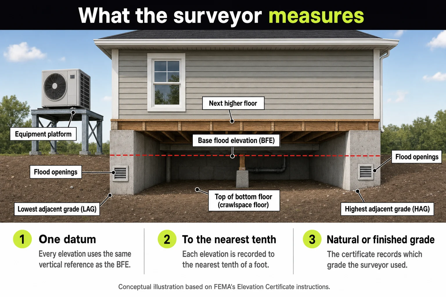
Every elevation uses the same vertical reference as the BFE, called a datum. Each is recorded to the nearest tenth of a foot, per the form instructions.
The main number is the top of the bottom floor, not counting an attached garage. For a crawlspace, the surveyor enters the lowest elevation of the top of the crawlspace floor, whether or not it has flood vents.
It also records the lowest platform or ground under the heating, cooling, plumbing and electrical equipment. A condenser on a low pad shows up. Some jurisdictions set a required height for equipment too, and the hub covers equipment and utilities.
For a crawlspace or enclosure, it records the square footage, the permanent flood openings within 1 foot above grade, and their net open area. Engineered vents need paperwork attached.
FEMA’s Technical Bulletin 1 warns that without clarifying comments, officials and insurance agents may judge an enclosure non-compliant. Part 3 covers how many vents you need.
What are highest and lowest adjacent grade?
Highest adjacent grade, or HAG, is the highest ground next to the walls of the building. Lowest adjacent grade, or LAG, is the lowest.
Natural or finished ground changes the answer. Under 44 CFR 59.1, HAG is the highest natural elevation of the ground before construction next to the proposed walls. Natural grade is the undisturbed ground, before any excavation or fill.
The certificate has Natural and Finished boxes for HAG and LAG. The surveyor records which grade was used. Ask your floodplain administrator which grade your community works from.
HAG is the measuring point where the map gives no BFE. The FIRM, or Flood Insurance Rate Map, is the flood map FEMA publishes for each community.
Zone AO is mapped with a flood depth instead of a BFE. There, 44 CFR 60.3(c)(7) sets the lowest floor above the HAG by at least the FIRM depth.
Zone A has no published BFE. There, FEMA’s Zone A guide says a community may require two or more feet above the HAG. That applies when no other data exists.
The hub covers how the elevation is set on those lots.
What does an elevation certificate cost?
Get quotes from licensed surveyors in your area. The fee is set between you and the surveyor, and FEMA’s fact sheet notes that a licensed professional may provide one for a fee.
Ask each surveyor how many certificates and visits the price covers, and whether it includes staking the BFE and the as-built certificate.
Who pays is a matter for your contract and your quote to the customer. Put the certificates on their own line in that quote, so the cost shows up before the foundation does. For a remodel or substantial improvement on an existing house, ask the floodplain office whether a certificate is already on file.
Does an elevation certificate lower flood insurance?
It can. The NFIP no longer requires a certificate to buy coverage. An owner can still send one to the insurer to see whether it affects the rate.
The jurisdiction may still require it for the permit. Two of its three jobs measure differently: permit approval and insurance pricing.
The jurisdiction compares the lowest floor to the BFE. FEMA’s rating looks at first floor height above the adjacent grade.
In our experience, you can do everything a jurisdiction requires and still pay a top level flood insurance premium. Compliance gets the permit, not the price. Part 4 covers flood insurance on new construction.
A certificate also does not change the map. Only a LOMA or LOMR-F from FEMA can remove the federal flood insurance requirement, and a lender can still require insurance afterward.
A LOMA, or Letter of Map Amendment, applies where the natural ground was already at or above the BFE. A LOMR-F, or Letter of Map Revision based on Fill, rests on permitted fill.
Fill is regulated, so bringing in dirt is not a shortcut out of the zone. Part 5 covers the LOMA and LOMR-F process.
Plain words for your customer: “The certificate proves how high the house sits. It doesn’t change the flood map, and it doesn’t set your insurance price. Get a quote from an insurance agent before you commit, and give them the certificate.”
What a SiteFacts Report does here, and what it doesn’t
A SiteFacts Report flags the mapped flood zone and the overlays that apply to a lot, and it gives you a jurisdiction call list. Each report is analyst verified and typically delivered in 7 to 10 business days.
It does not survey a lot, prepare an elevation certificate or make a flood determination. A surveyor does that work.
Know what applies to the lot before you quote
Order a SiteFacts Report on the lot before you quote. The certificate still comes from a surveyor, and the floodplain administrator decides when you need it.
Terms on this page
- BFE (base flood elevation): the height floodwater reaches in a flood with a 1 percent chance of happening in any year. It is a height, not a depth.
- CFR (Code of Federal Regulations): the set of federal rules, including FEMA’s floodplain rules in 44 CFR.
- EC (elevation certificate): FEMA’s form, signed by a licensed surveyor, engineer or architect, that records how high a building sits compared with the BFE.
- FEMA (Federal Emergency Management Agency): the federal agency that publishes flood maps.
- FIRM (Flood Insurance Rate Map): the flood map FEMA publishes for a community.
- HAG and LAG (highest and lowest adjacent grade): the highest and lowest ground next to the walls of a building.
- LOMA (Letter of Map Amendment): FEMA’s letter removing a lot or building from the high-risk area when the natural ground was already at or above the BFE.
- LOMR-F (Letter of Map Revision based on Fill): the same kind of removal where permitted fill raised the ground.
- NFIP (National Flood Insurance Program): the federal program that sets community floodplain rules and offers flood insurance.
- Substantial improvement: work that costs 50 percent or more of a structure’s market value before the work starts.
- Zone A and Zone AO: high-risk flood zones. Zone A has no published BFE. Zone AO is mapped with a flood depth instead.
Part 3: Flood Vents: Requirements, Engineered vs Non-Engineered, and How Many You Need
Last reviewed: 2026-11-05. Flood rules change and vary by jurisdiction. Confirm with your local floodplain administrator.
Your customer’s lot is in a flood zone, and the floor plan has a crawlspace or an attached garage. Before you price the foundation, you need to know how many flood vents it takes and what kind.
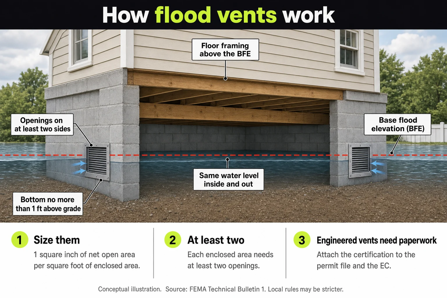
Flood vents are openings that let floodwater flow into and out of a crawlspace or garage below the base flood elevation, or BFE. In inland A zones, non-engineered flood vents need 1 square inch of net open area per square foot of enclosed area. They also need at least two openings, with the bottom of each no more than 1 foot above grade.
Table of contents
- What are flood vents and why are they required?
- Which spaces need flood vents?
- How many flood vents do I need?
- Engineered vs non-engineered flood vents
- Where do flood vents go?
- How do flood vents show up on the elevation certificate?
- What materials can sit below the BFE?
- Do local rules add to the federal ones?
- What a SiteFacts Report does here
- Terms on this page
What are flood vents and why are they required?
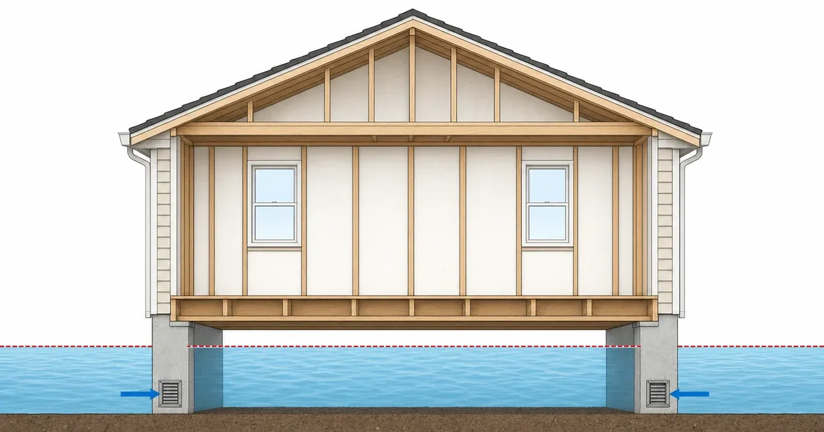
A flood vent is an opening in a foundation or enclosure wall that lets floodwater pass through on its own. The elevation certificate, or EC, instructions from FEMA, the Federal Emergency Management Agency, say a permanent flood opening allows the free passage of water automatically in both directions without human intervention.
The reason is pressure. The federal rule, 44 CFR 60.3(c)(5), covers fully enclosed areas below the lowest floor that are used only for parking, building access or storage. They must be designed to equalize hydrostatic flood forces on the exterior walls.
Hydrostatic forces are the pressure standing water puts on a wall. CFR stands for the Code of Federal Regulations. Where a lot has no published BFE, see the hub on Zone A with no BFE.
The BFE is the height floodwater reaches in a flood with a 1 percent chance of happening in any year, according to FEMA’s glossary.
Which spaces need flood vents?
Crawlspaces, attached garages and other enclosed areas below the BFE. FEMA’s Technical Bulletin 1 (March 2020), or TB 1, replaced the 2008 edition.
It says the requirement applies whether the walls are crawlspace, load-bearing or non-load-bearing walls. Its list includes crawlspaces, attached garages and detached garages.
Its sidebar on conditioned crawlspaces says all crawlspaces in the high-risk flood area need flood openings. They must meet the National Flood Insurance Program, or NFIP, rules and building codes.
Some things people count as vents do not count. TB 1 says air vents usually sit too high on the wall. An access door does not qualify unless it has an opening that lets water in and out on its own.
A garage door with no openings does not count, because someone has to open it. TB 1 puts garage openings in the exterior walls, and in the garage door only when there is not enough wall area. It advises against putting one in the wall between the garage and the living space unless the device is designed for fire separation.
A crawlspace below grade on all sides is a basement, which is a different problem. The hub covers basements in a flood zone.
Plain words for your customer: “Even if we plan to condition the crawlspace, it still needs flood vents. The regular air vents usually don’t count, and the access door only counts if it has an opening in it. We’ll set the vent locations once the final grades are set.”
How many flood vents do I need?
Under 44 CFR 60.3(c)(5) and TB 1, you need enough openings to give 1 square inch of net open area for every square foot of enclosed area, with at least two openings in each enclosed area. For non-engineered vents, TB 1 says to measure the enclosed area on the outside of the enclosure walls.
Net open area is what is left after fixed blades and insect screens are subtracted. The product’s rated net open area matters, not the size of the hole.
Here is the arithmetic for a crawlspace that measures 1,200 square feet on the outside of its walls.
| Enclosed area | Net open area needed | Vent rating | Vents |
|---|---|---|---|
| 1,200 square feet | 1,200 square inches (1 per square foot) | 200 square inches each (example only) | 6 (1,200 divided by 200) |
The model codes and the EC ask for openings on at least two walls, so the six still go on at least two different walls.
Check the rated net open area of the product you plan to use and run the same math.
If the math came out to one vent, you would still need two. TB 1 says each enclosed area needs its own openings, so a crawlspace and an attached garage are counted separately.
Engineered vs non-engineered flood vents
A non-engineered vent has no moving parts and follows the 1 square inch rule. An engineered vent has moving parts and needs certification. TB 1 says flood openings with moving parts should be certified as engineered openings.
For engineered vents, TB 1 gives two routes. One is an evaluation report from the ICC Evaluation Service, or ICC-ES, part of the International Code Council. An equivalent report from another certification group also works.
The other is a design certified by a registered design professional for the specific building and site. Under 44 CFR 60.3(c)(5), that means a registered professional engineer or architect.
Expect paperwork. TB 1 notes that the model building codes ask for a design statement from a registered design professional. It goes with the permit documents when engineered openings are proposed.
The codes are the International Building Code (IBC) and the International Residential Code (IRC). ICC-ES evaluation reports satisfy the design statement. Confirm which codes your jurisdiction has adopted.
The certificate needs it too. FEMA’s EC instructions say flood openings cannot be considered engineered without documentation. For engineered vents, the rated area from the evaluation report or the engineer’s certification goes in item A8.e, with that documentation attached.
Where do flood vents go?
Low on the wall, and on more than one side.
On height, TB 1 says the bottom of each opening must be no higher than 1 foot above the highest of three levels. They are the final interior grade, the final exterior grade and the floor right under the opening, per TB 1 section 8.2. TB 1 also says final grades must be known before you place openings in a perimeter wall.
On sides, TB 1 says the model codes ask for openings on different sides of each enclosed area. The elevation certificate asks the same question.
On size, TB 1 quotes the 2018 IRC as adding a minimum of 3 inches in any direction. Which IRC edition applies depends on your state, so confirm it.
How do flood vents show up on the elevation certificate?
In Section A, items A8 for a crawlspace or enclosure and A9 for an attached garage. The EC is FEMA’s form that records how high a building sits compared with the BFE.
A licensed surveyor signs it, or an engineer or architect where state law allows. Part 2 covers what the surveyor measures.
On FEMA’s 2022 edition of the form, A8 asks for the enclosed area in square feet, measured from the outside of the walls. It asks for the number of openings within 1 foot above adjacent grade. It asks for the net open area of non-engineered ones in square inches (A8.d).
It asks for the rated area of engineered ones in square feet (A8.e). A9 repeats the items for an attached garage. These are in FEMA’s EC instructions.
Ask the surveyor to use the printing your jurisdiction accepts. Openings more than 1 foot above adjacent grade are not counted. With no qualifying openings, the instructions say to enter 0 (zero), not N/A.
TB 1 was written for the older 2015 form, so its item numbers differ. It says notes in Section D should name the manufacturer and model of engineered vents.
In 2020, TB 1 warned that without clarifying comments, officials may treat the enclosure floor as the lowest floor. FEMA’s current Risk Rating 2.0 page says proper flood openings in a crawlspace help reduce flood damage and potentially decrease the cost of flood insurance.
What materials can sit below the BFE?
Flood damage-resistant ones, under 44 CFR 60.3(a)(3). FEMA’s Technical Bulletin 2 (2025) rates I-joists, OSB (oriented strand board) and particle board Unacceptable below BFE. The hub covers materials in Step 5.
Do local rules add to the federal ones?
They can, and some narrow the options. The federal numbers are the floor, so check the local code and the state building code edition.
In the Pacific Northwest, Lane County, Oregon, has the administrator obtain an elevation certificate once the lowest floor is placed. It records the location and height of all flood openings, under Ordinance 21-07. It covers unincorporated Lane County only.
In the Southeast, the City of Albany and Dougherty County, Georgia, publish joint guidance. It says vents must be in a permanent open position with the tabs broken off.
Vents at the wrong height or location, or not locked open, cannot be counted. That goes for the surveyor filling out the EC and the building inspector, per the Albany and Dougherty County guidance. It is dated October 2020, so confirm the current ordinance.
In the Midwest, a state can limit what FEMA’s guidance allows. The Minnesota DNR, the state’s Department of Natural Resources, says the options in FEMA’s Technical Bulletin 11, which covers below-grade crawlspaces, are not allowed in Minnesota.
What a SiteFacts Report does here, and what it doesn’t
A SiteFacts Report flags the mapped flood zone and the overlays that apply to a lot. It also gives you a jurisdiction call list. Each report is analyst verified and typically delivered in 7 to 10 business days.
It does not size flood vents, design a foundation, survey a lot or prepare an elevation certificate.
Know what applies to the lot before you quote
Order a SiteFacts Report on the lot before you quote the foundation. The vent standard and the permit path remain the floodplain administrator's call.
Terms on this page
- ICC-ES (ICC Evaluation Service): the group that issues evaluation reports for products such as engineered flood vents.
- Net open area: the open area of a vent after fixed blades, screens and other obstructions are subtracted.
- TB 1 (Technical Bulletin 1): FEMA’s guidance on flood openings in foundation walls and walls of enclosures.
Part 4: Flood Insurance on New Construction: Why Meeting Code Doesn't Set Your Premium
Last reviewed: 2026-11-05. Flood rules change and vary by jurisdiction. Confirm with your local floodplain administrator and an insurance agent.
A customer brings you a lot in a flood zone and asks what flood insurance will cost if you build the house to code. Many customers expect the answer to be normal.
Your jurisdiction decides whether you can build and how high. Your insurer decides what flood coverage costs.
Under Federal Emergency Management Agency (FEMA) Risk Rating 2.0 pricing, each building is rated on traits like first floor height above the ground. An elevation certificate is optional for federal flood insurance, but it can affect the rate.
An elevation certificate, or EC, is the FEMA form that records how high a building sits compared with the base flood elevation, or BFE. The BFE is the height floodwater reaches in a flood with a 1 percent chance of happening in any year. A licensed surveyor signs the EC, or an engineer or architect where state law allows.
This page shows why the two answers differ and what to tell your customer before you quote. It expands the insurance section of Part 1.
Table of contents
- Who decides what: the jurisdiction or the insurer?
- How does Risk Rating 2.0 price a new home?
- Why can a house that meets code still get a high premium?
- Do I need a flood insurance elevation certificate?
- Does building higher than code lower the premium?
- Will my customer’s lender require flood insurance?
- NFIP or private flood insurance: who sets the rules?
- What should I do before I quote a flood zone build?
- What a SiteFacts Report does here
- Terms on this page
Who decides what: the jurisdiction or the insurer?
The jurisdiction decides whether you get the permit and how the house has to be built. The insurer decides what coverage costs. They use different rulebooks and look at different numbers.
| The jurisdiction | The insurer | |
|---|---|---|
| Who decides | The floodplain administrator, under the local ordinance | FEMA for a National Flood Insurance Program (NFIP) policy, or a private insurer for a private policy |
| What they decide | Whether you get the permit, and how the house must be built | What coverage costs |
| What they measure | The lowest floor against the BFE, plus any local freeboard | First floor height above the adjacent grade, along with other building traits |
| Document used | The permit file and the elevation certificate | The building’s rating, and an elevation certificate if the owner submits one |
| What the flood map does | Drives the local building rules | Informs the models behind the NFIP rate |
Freeboard is extra height above the BFE that a community requires as a safety margin. The NFIP is the federal program that sets floodplain rules for communities and offers flood insurance.
FEMA’s Risk Rating 2.0 FAQ says flood map data informs local floodplain management building requirements and mandatory purchase requirements, and also informs the models used to develop rates. The map feeds both sides. It does not make them the same question.
On the permit side, SiteFacts has seen a Texas lot in Zone AE where the existing grade already sat at the BFE, so the lowest floor only had to rise by the local freeboard.
How does Risk Rating 2.0 price a new home?
It rates the building itself, not just the flood zone on the map. FEMA’s Risk Rating 2.0 fact sheet says the rating is specific to the building, and that new policies effective on or after October 1, 2021, are priced under it.
The same FAQ lists the variables as flood types, distance from a flooding source, frequency of flood, elevation and the cost to rebuild a property. FEMA’s April 2022 discount guide adds foundation type, flood openings, machinery and equipment, and number of floors.
So there is no single Zone AE price. Zone AE is a high-risk zone where the BFE is printed on the map, and FEMA rates the building, not just the zone.
Some of those variables are your decisions: the foundation, the openings, the first floor height and where the equipment sits. Others, like flood frequency and distance from the water, belong to the lot.
Why can a house that meets code still get a high premium?
Because the permit and the premium measure different things. Compliance gets the permit. It does not set the price.
The jurisdiction measures the lowest floor against the BFE, plus any local freeboard. FEMA’s rating uses first floor height, which its discount guide defines as the height of the building’s first lowest floor above the adjacent grade.
In SiteFacts’ reading, these are two measurements of the same floor, from two starting points. One starts at the flood elevation. The other starts at the ground.
For example, say the BFE is 100 feet, the ground at the house sits at 99 feet, and the jurisdiction requires 2 feet of freeboard. The lowest floor has to reach 102 feet, which puts it 3 feet above the ground.
Now say the ground sits at 100 feet. The floor still has to reach 102 feet to meet the permit, but it is only 2 feet above the ground.
The permit asks whether the floor is at 102. The rating asks how far the floor is above the ground. Those are different questions.
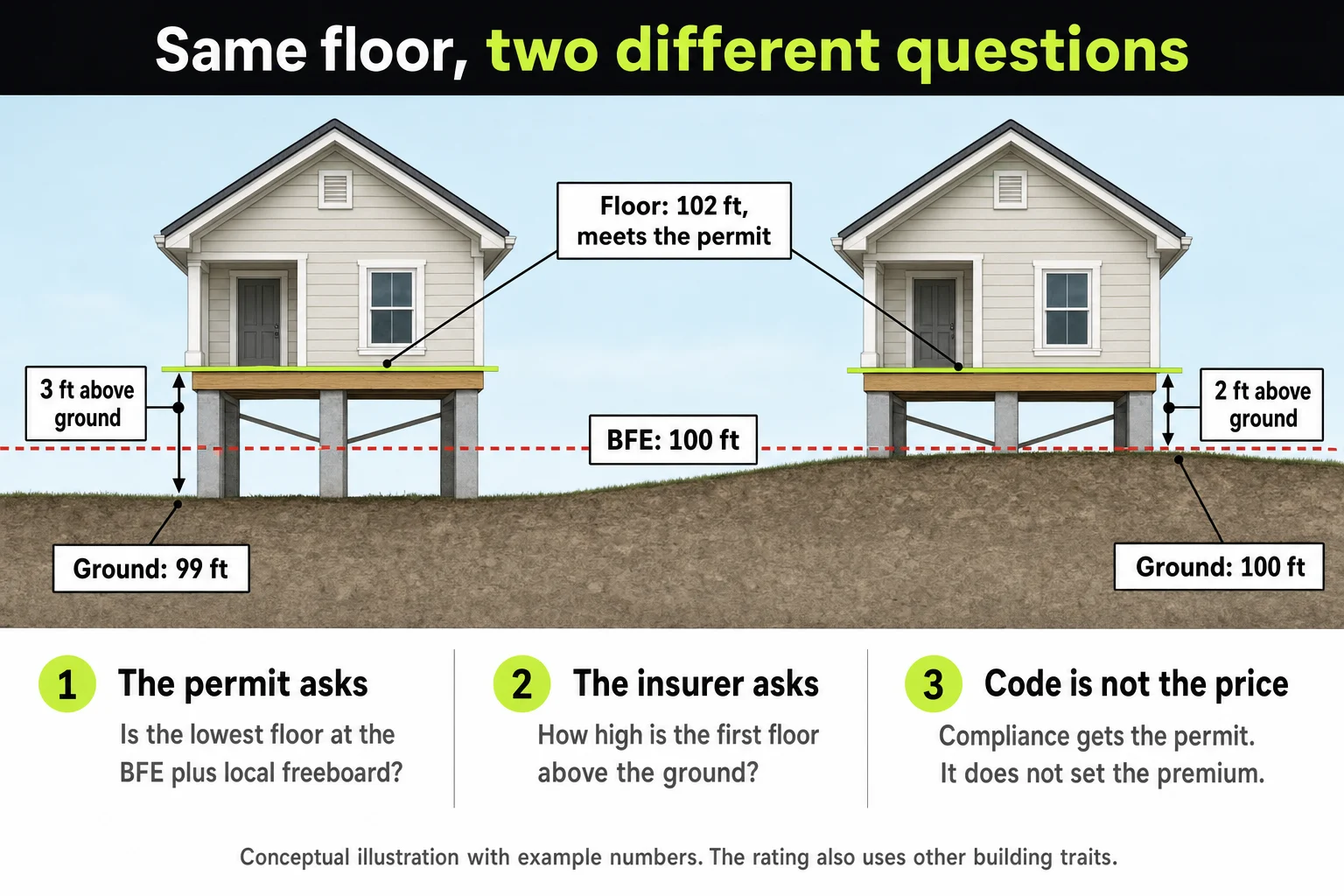
In our experience, you can do everything a jurisdiction requires and still pay a top level flood insurance premium.
Compliance still matters. FEMA’s FAQ says buildings that are not in compliance with community floodplain management regulations are ineligible for the CRS premium discount. The CRS, or Community Rating System, is the FEMA program that gives discounts in participating communities.
If you tell a customer insurance will be normal and the quote comes back high, you are the one who has to explain it.
Plain words for your customer: “Building to code gets you the permit. It doesn’t set your insurance price. We’ll tell you what the jurisdiction requires. The insurer tells you what it costs. Get a quote from an insurance agent before you commit, and bring the elevation certificate once the surveyor has done one.”
Do I need a flood insurance elevation certificate?
No, not to buy NFIP flood insurance. FEMA’s Risk Rating 2.0 FAQ says an EC is no longer required to purchase coverage, and that FEMA uses its own tools and resources to determine elevation data for a building.
An owner can still submit one to the NFIP insurer to see whether it will affect the rate. The same FAQ says ECs continue to be used for floodplain management building requirements.
So one form does two jobs. The jurisdiction can require it as the compliance record. The insurer treats it as optional rating evidence.
Local rules vary. In Lane County, Oregon, the code has the administrator obtain an EC once the lowest floor is placed and before further vertical construction, and an as-built EC before the final inspection, under Lane Code 16.244. Ada County, Idaho, says it will not issue a certificate of occupancy until the final elevation certificate is submitted.
A completed EC does not expire unless the building physically changes in a way that invalidates the information on the form, and a change of owner does not void it, according to FEMA’s EC instructions. SiteFacts’ advice is to keep the final certificate on file so you can hand it to the customer’s insurance agent. Part 2 covers timing and cost.
Does building higher than code lower the premium?
Generally, yes, in direction. FEMA’s April 2022 discount guide shows the rate dropping as first floor height rises. How much it drops for a given house comes from an insurer’s quote.
FEMA’s FAQ says mitigation efforts such as elevating a building, installing proper flood openings in a crawlspace or enclosure, and elevating certain machinery and equipment will help reduce flood damage and potentially the cost of flood insurance.
FEMA’s rating documents give the variables and the direction, not a conversion from a freeboard number to a premium. Do not promise your customer a saving. Send them to an insurance agent for the number. Part 3 covers how many vents.
Will my customer’s lender require flood insurance?
Often, for the house. FEMA says Congress mandates that federally regulated or insured lenders require flood insurance for buildings in the Special Flood Hazard Area, or SFHA, when the loan is federally backed. The SFHA is the land FEMA maps as having a 1 percent chance of flooding in any year.
Lenders can ask for more. FEMA’s FAQ says lenders retain the right to require flood insurance beyond what federal law requires.
The federal rule attaches to a building, not to bare ground. In the Code of Federal Regulations, or CFR, the Federal Deposit Insurance Corporation (FDIC) rule at 12 CFR 339.3(a) says coverage is limited to the building and any personal property that secures a loan, “and not the land itself.”
How a lender treats a lot loan or a construction loan in a flood zone is the lender’s to explain, so ask before the customer closes.
NFIP or private flood insurance: who sets the rules?
FEMA rates NFIP policies. An insurer underwrites a private flood policy, and a state insurance department regulates it, not the floodplain administrator.
Florida shows how one state does it. Florida’s insurance regulator says state law requires most flood insurance policy types to be at least as broad as the NFIP, and that section 627.715, Florida Statutes, sets guidelines for private flood filings. Other states set their own rules.
On the lender side, the FDIC rule says a lender it supervises must accept a private policy that meets the definition in 12 CFR 339.2 and the coverage requirements in 339.3(a), under 12 CFR 339.3(c).
Ask each insurer what it needs, such as an elevation certificate or a minimum floor height.
What should I do before I quote a flood zone build?
SiteFacts’ advice, not a rule: get the insurance question answered before you lock the floor height and foundation.
Ask the customer to call an insurance agent early, with the lot’s address and the floor plan, and get a quote. That quote is the number. Your price for the foundation is a different number.
Give the agent the elevation data from the surveyor, and the elevation certificate when you have it. Then tell the customer plainly which questions belong to the jurisdiction, which to the lender and which to the insurer. Part 1 covers the permit side.
Do not promise a premium in the sales conversation or the contract. You control the build. You do not control the rate.
What a SiteFacts Report does here, and what it doesn’t
A SiteFacts Report flags the mapped flood zone and the overlays that apply to a lot, and it gives you a jurisdiction call list. Each report is analyst verified and typically delivered in 7 to 10 business days.
It does not price flood insurance, predict a premium, survey a lot, prepare an elevation certificate or make a flood determination. An insurance agent quotes the premium, a surveyor prepares the certificate, and the floodplain administrator decides what the lot needs.
Know what applies to the lot before you quote
Order a SiteFacts Report on the lot before you quote. It flags the mapped flood zone. The premium comes from an insurance agent.
Terms on this page
- BFE (base flood elevation): the height floodwater reaches in a flood with a 1 percent chance of happening in any year.
- CRS (Community Rating System): the FEMA program that gives premium discounts in participating communities.
- EC (elevation certificate): FEMA’s form that records how high a building sits compared with the BFE.
- FDIC (Federal Deposit Insurance Corporation): the federal bank regulator whose lender rule is cited here.
- FEMA (Federal Emergency Management Agency): the federal agency that sets national flood rules and runs the NFIP.
- First floor height: the height of a building’s first lowest floor above the adjacent grade.
- Freeboard: extra height above the BFE used as a safety margin.
- NFIP (National Flood Insurance Program): the federal program that sets floodplain rules and offers flood insurance.
- Risk Rating 2.0: FEMA’s method for pricing NFIP policies, specific to each building.
- SFHA (Special Flood Hazard Area): the land FEMA maps as having a 1 percent chance of flooding in any year.
Part 5: LOMA vs LOMR-F: How to Get a Lot Out of the Flood Zone
Last reviewed: 2026-11-05. Flood rules change and vary by jurisdiction. Confirm with your local floodplain administrator.
Your customer brings you a lot in a flood zone and asks whether it can be taken out of the zone. Sometimes it can, through a letter from the Federal Emergency Management Agency (FEMA), and which letter depends on how the ground got to its height.
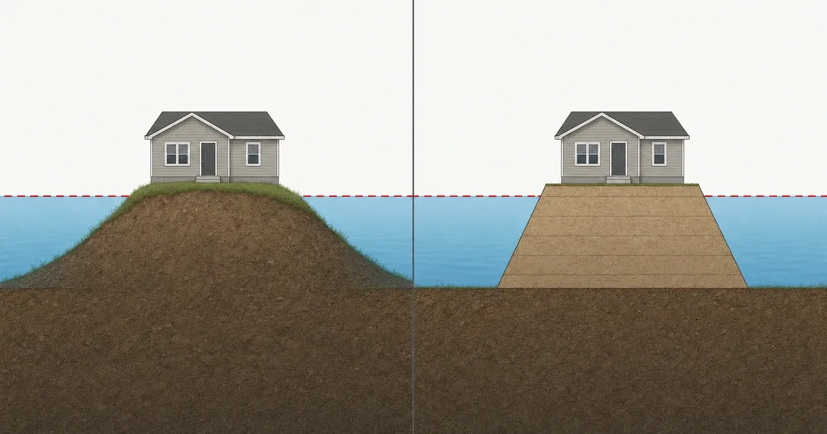
A LOMA (Letter of Map Amendment) is FEMA’s letter removing a lot or building from the high-risk flood area because the natural ground was already at or above the base flood elevation. A LOMR-F (Letter of Map Revision based on Fill) does the same where permitted fill raised the ground. A LOMR (Letter of Map Revision) redraws the map itself.
The base flood elevation, or BFE, is the height floodwater reaches in a flood with a 1 percent chance of happening in any year, according to FEMA’s glossary. The high-risk area FEMA maps around that flood is the Special Flood Hazard Area, or SFHA.
These letters record how the ground sits. They are not a shortcut around the flood rules.
Table of contents
- What is a LOMA?
- What is a LOMR-F, and why is fill not a shortcut?
- What is a LOMR, and why do maps change anyway?
- How do I get a lot out of a flood zone, and what does it cost?
- Does a LOMA end flood insurance?
- Who does the work?
- What a SiteFacts Report does here
- Terms on this page
What is a LOMA?
A LOMA is FEMA’s letter saying a lot or building sits on naturally high ground, not ground raised by fill, and would not be flooded by the base flood. FEMA’s change your flood zone page describes it that way.
The test is elevation. For a building, the lowest ground touching it must be at or above the BFE. For a lot, the lowest point on the lot must be at or above the BFE, under FEMA’s LOMA and LOMR-F page.
FEMA runs the two tests separately. A letter that is granted officially removes the property or building from the SFHA.
In our experience, this is the case where the flood map was too coarse to show the high ground. If part of the lot sits below the BFE, the lot as a whole does not pass the test.
Plain words for your customer: “A LOMA is for ground that was always high. A surveyor measures it, and FEMA decides. If your lot sits low, we plan the house around the flood rules instead.”
What is a LOMR-F, and why is fill not a shortcut?
A LOMR-F is FEMA’s letter for a lot or building that fill has raised above the BFE. FEMA describes it for property that has been elevated by earthen fill and would not be flooded by the base flood. The fill comes first, and the LOMR-F comes second.
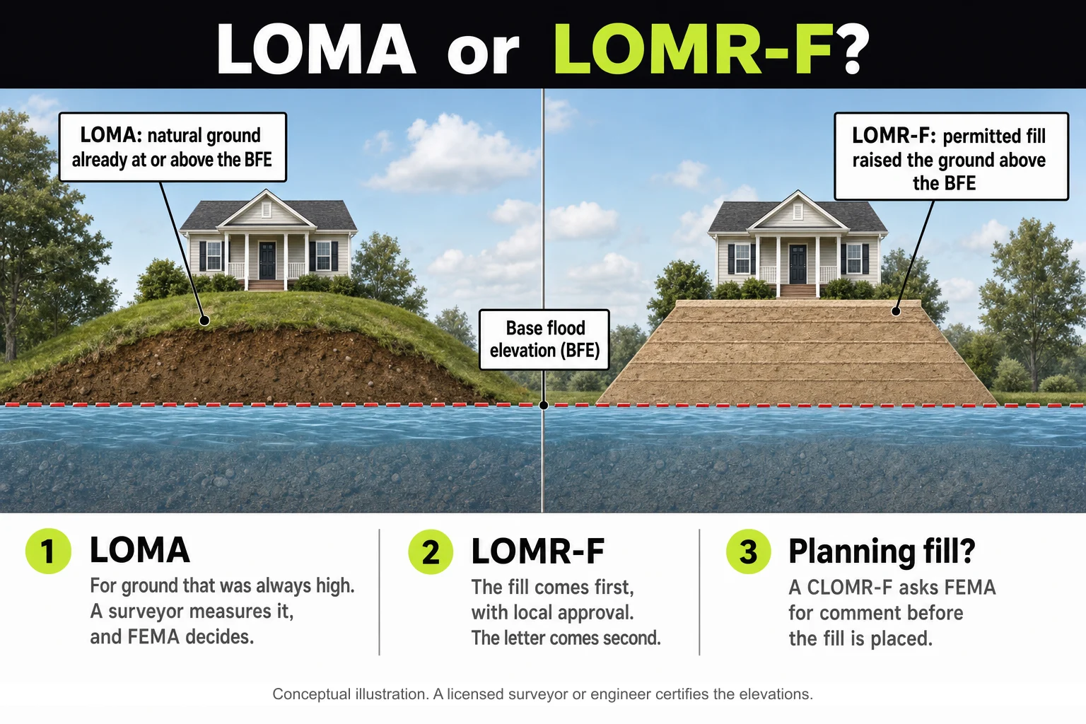
Before placing fill, a builder can ask FEMA for comment with a CLOMR-F, a Conditional Letter of Map Revision based on Fill, which the Code of Federal Regulations (CFR) lists with the other letters, in 44 CFR 72.4(g).
Placing the fill is its own approval, and it is where most of the trouble sits. In our experience, many jurisdictions have stiff rules on importing fill into flood zones, so bringing in dirt is not a plan for getting a lot out of the zone.
The rules start at the federal level. In an adopted floodway, which is the channel and nearby land that must stay clear to carry a flood, federal floodplain rules have communities prohibit fill unless engineering analysis shows no increase in flood levels, under 44 CFR 60.3(d)(3).
Wisconsin shows how a state applies it. Development in a Wisconsin floodway needs an approved encroachment analysis showing no change in the BFE, or an approved Letter of Map Revision from FEMA, according to Wisconsin DNR.
Local permits come next. In Garden City, Idaho, grading or placing fill in the floodplain takes the City’s full floodplain and floodway application.
Some codes also make you take material back out. Corvallis, Oregon, requires “volumetric exchange” in some floodplain areas, which means an equal amount of material must be removed from the same property for any fill, so the floodplain’s volume is not reduced, under the Corvallis land development code.
Part 1 covers the rest in Step 6, bringing in fill.
Plain words for your customer: “Bringing in dirt doesn’t change the map on its own. The city has to approve the fill first. Once it’s placed and a surveyor certifies the new ground, we can ask FEMA for a letter.”
What is a LOMR, and why do maps change anyway?
A LOMR is FEMA’s letter officially revising the current map to show changes to floodplains, floodways or flood elevations. FEMA’s LOMR and CLOMR page says a community or an individual can request one. In our experience, a LOMR is usually a bigger engineering job than a LOMA.
A CLOMR, or Conditional Letter of Map Revision, comes before construction. It is FEMA’s comment on whether a proposed project would meet minimum National Flood Insurance Program (NFIP) standards, according to the same page.
For a LOMR or CLOMR request, 44 CFR 72.4(h) gives FEMA 60 days to say whether the request is adequate and 90 days to respond once it has adequate information and the fee.
Maps also change without anyone filing a letter. FEMA’s Map Service Center warns that what you download or print may be superseded by new maps over time. When new FEMA flood maps are adopted, FloodSmart’s flood zone page says insurance requirements and the cost of a policy may change.
On Oregon’s McKenzie River, FEMA’s pending flood map update was issued as preliminary maps in early 2020, the September 2020 Holiday Farm Fire changed the watershed, and the preliminary data has been reissued since. A map you pulled for one purchase may not be the one that governs your permit.
So pull the current effective map panel when the customer brings you the lot, and again before design and before you apply for the permit. Ask the floodplain administrator whether a map update, a LOMR or a local study is pending. Part 1 walks through it in Step 1, the current flood map.
How do I get a lot out of a flood zone, and what does it cost?
For a LOMA, FEMA charges no review fee. For a LOMR-F, FEMA charges one. Federal rule 44 CFR 72.5(c) exempts LOMA requests from review and processing fees, while 44 CFR 72.3(c)(1) sets flat user fees for LOMR-F requests on single lots or structures.
Check FEMA’s current fee schedule before you quote a number to a customer, because the amount is not in the rule.
The surveyor or engineer who certifies the elevations is a separate cost. Get quotes before you tell the customer what the whole path costs.
The path runs in this order. Pull the current map panel and the BFE for the lot. Have a licensed surveyor or engineer measure and certify the ground.
File the request with FEMA, which takes applications through its online application system, according to the change your flood zone page. FEMA names the MT-EZ form for a LOMA on a single residential lot or building and the MT-1 form for multiple lots and for all LOMR-F requests, per its LOMA and LOMR-F page.
The FEMA clock starts late, and it differs by letter. For LOMA and LOMR-F requests, and their conditional versions, 44 CFR 72.4(g) has FEMA notify the requester and the community within 30 days whether the submittal is adequate. FEMA then responds within 60 days of receiving adequate information and the fee.
The 60 days start when FEMA has complete data, not when you first submit. LOMR requests run on the 60 and 90 day clock described above.
Your community may want to see a LOMR-F request first. In Lafayette, Louisiana, the local floodplain office reviews the completed LOMR-F application, and a community official signs a Community Acknowledgement Form that is required before the application goes to FEMA. The floodplain administrator has a 15 business day initial review time, according to Lafayette Consolidated Government’s page.
Other communities may work differently, so confirm this with your floodplain administrator, along with which local rules still apply to the lot after a letter is issued.
Does a LOMA end flood insurance?
A LOMA or LOMR-F ends the federal requirement to buy flood insurance, but it does not stop a lender from requiring it. FEMA’s LOMA and LOMR-F page says the mortgage lender keeps the right to require flood insurance.
A LOMR changes the map itself, so ask the lender how a map revision affects the requirement on a specific lot. Confirm this before you tell a customer.
What the quote will look like afterward is a separate question for an insurance agent, so do not promise a customer a savings. Part 4 covers why code doesn’t set the premium.
Plain words for your customer: “A letter from FEMA can end the federal requirement. Your lender can still ask for flood insurance, so ask them before you count on dropping it.”
Who does the work?
A licensed surveyor or an engineer does the work, not SiteFacts. SiteFacts does not prepare, file or certify a LOMA, LOMR-F or LOMR request.
FEMA’s LOMA and LOMR-F page asks for elevation information certified by a licensed land surveyor or registered professional engineer, to the nearest tenth of a foot, on the NFIP map datum.
The instructions for the elevation certificate (EC), FEMA’s form that records how high a building sits compared with the BFE, add that an architect can certify where state law authorizes it, per FEMA’s EC instructions. Ask the professional which one your state allows.
Licensed professionals can also file LOMA requests through eLOMA, an online route FEMA offers them, according to the change your flood zone page.
What a SiteFacts Report does here, and what it doesn’t
A SiteFacts Report flags the mapped flood zone and the overlays that apply to a lot, and it gives you a jurisdiction call list. Each report is analyst verified and typically delivered in 7 to 10 business days.
It does not measure the ground, so it cannot say whether a lot qualifies for a LOMA. It does not prepare an elevation certificate, file a LOMA, LOMR-F or LOMR, or make a flood determination. A surveyor or engineer does that work, and the floodplain administrator decides what the lot needs.
Know what applies to the lot before you quote
Order a SiteFacts Report on the lot before you quote. The map change path and the permit path remain the floodplain administrator's and FEMA's call.
Terms on this page
- BFE (base flood elevation): the height floodwater reaches in a flood with a 1 percent chance of happening in any year. It is a height, not a depth.
- CLOMR (Conditional Letter of Map Revision): FEMA’s comment on whether a proposed project would meet minimum National Flood Insurance Program standards.
- EC (elevation certificate): FEMA’s form that records how high a building sits compared with the BFE.
- Floodway: the channel and nearby land that must stay clear to carry the base flood.
- LOMA (Letter of Map Amendment): FEMA’s letter removing a lot or building from the high-risk area when the natural ground was already at or above the BFE.
- LOMR (Letter of Map Revision): FEMA’s letter changing the flood map itself.
- LOMR-F (Letter of Map Revision based on Fill): the same kind of removal where permitted fill raised the ground.
- NFIP (National Flood Insurance Program): the federal program that sets floodplain rules for communities and offers flood insurance.
- SFHA (Special Flood Hazard Area): the land FEMA maps as having a 1 percent chance of flooding in any year.
Part 6: How to Build a House in a Flood Zone: Design Decisions in Order
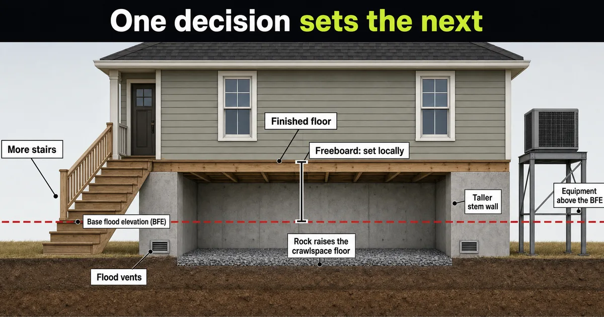
Last reviewed: 2026-11-05. Flood rules vary by jurisdiction and change, so confirm with your local floodplain administrator.
A customer brings you a lot in a flood zone and a floor plan. The first idea in the room is usually to raise the pad and build on level ground.
How to build a house in a flood zone starts with the required floor height, not the yard. The floor goes at the base flood elevation (BFE) plus any local freeboard. That height sets the wall height, and the wall height shapes the crawlspace, the vents and the fill plan, so confirm each step with the floodplain administrator.
The Federal Emergency Management Agency (FEMA) defines the BFE as the height floodwater reaches in a flood with a 1 percent chance of happening in any year, according to FEMA’s glossary.
This page covers a house on a crawlspace foundation in an inland flood zone. Coastal zones add rules.
Table of contents
- Where does a flood zone house design start?
- Can I just raise the pad?
- How tall will the foundation walls be?
- How deep and tall can the crawlspace be?
- What does this look like on a real house?
- Would the same house be harder to build today?
- What balances fill you bring in?
- What do stairs and decks add?
- Are there other ways to get the floor up?
- What about materials, equipment and the final certificate?
- What does a SiteFacts Report do here, and what doesn’t it do?
- Terms on this page
In Part 5, a LOMA is a Letter of Map Amendment and a LOMR-F is a Letter of Map Revision based on Fill.
Where does a flood zone house design start?
It starts with the required floor height, which the floodplain administrator, the local official who runs the floodplain rules, sets from the BFE plus local freeboard. Freeboard is extra height above the BFE used as a safety margin. FEMA’s glossary says the National Flood Insurance Program (NFIP) does not require freeboard, but communities are encouraged to adopt at least one foot.
Required floor height is set locally, and the numbers differ from place to place. In SiteFacts’ review of published local and state floodplain rules, the City of Dunedin, Florida, requires the lowest floor at no less than the BFE plus 1 foot, according to the City’s elevation certificate form. Wisconsin state rules require new or substantially improved structures in the floodplain to have the first floor two feet above the BFE.
In Georgia, a joint Albany and Dougherty County guide dated October 2020 says construction must be elevated at least 1 foot above the BFE in the city and at least 3 feet in the county. Two lots with the same BFE can need floors 2 feet apart, so confirm the current ordinance and get the number from the floodplain administrator before you price the foundation.
If the map shows no BFE, as in Zone A, often someone has to establish one first, and some places set a height above the highest adjacent grade instead, according to FEMA’s Zone A guide.
| Order | Decision | What it forces next |
|---|---|---|
| 1 | Required floor height | The wall height |
| 2 | Foundation wall height against existing grade | Whether engineering is needed, and how many stairs |
| 3 | Crawlspace depth and interior grade | Whether rock or fill goes inside |
| 4 | Flood vents | Where the openings go |
| 5 | Fill and storage review | Whether the yard can change at all |
| 6 | Materials and framing | What has to sit above the BFE |
| 7 | Equipment heights | Where units and ductwork go |
| 8 | Stairs, decks and how the house looks | More steps and higher decks |
| 9 | Final elevation certificate | A surveyor checks what was built |
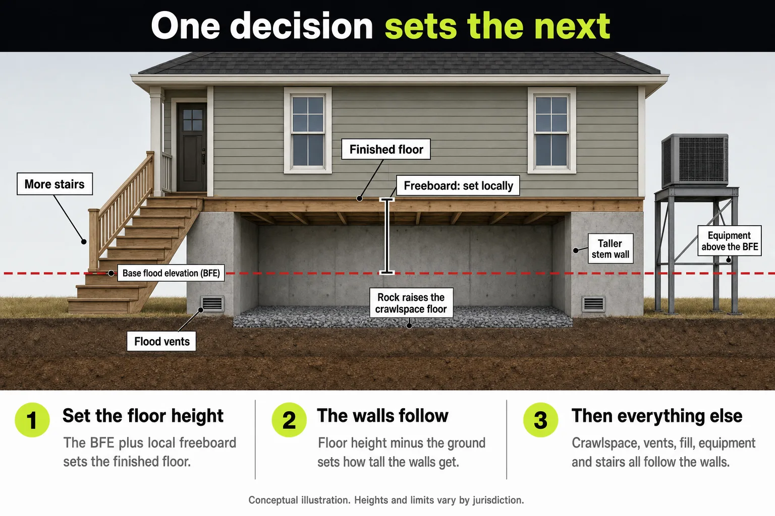
Can I just raise the pad?
Possibly, but ask the floodplain administrator before you design around it. Whether you can fill in a floodplain depends on the place. Some cap the rise in flood levels, some require removing an equal volume, and some prohibit fill in mapped areas, as the examples below show.
A floodway is the channel and nearby land that must stay clear to carry a flood. In an adopted floodway, 44 CFR 60.3(d)(3) has communities prohibit encroachments, including fill, unless engineering analysis shows no increase in flood levels. CFR is the Code of Federal Regulations.
Where the map shows BFEs but no floodway, 44 CFR 60.3(c)(10) allows fill only if its cumulative effect does not raise the base flood more than one foot at any point in the community.
Fill also takes up room floodwater would have used, so some places make you replace it. In Oregon, FEMA told cities and counties to choose, by December 1, 2024, a path that results in no net loss of flood storage, streamside habitat and water quality. That applies to flood hazard areas in all or part of 31 Oregon counties, as of the state’s December 2024 summary, so confirm the current status.
A pad does not change the map. The lot stays mapped until FEMA issues a letter that changes it, and a LOMR-F covers permitted fill only, as FEMA’s change your flood zone page explains. A new effective flood map can also change it, per FEMA’s Map Service Center.
In our experience, even ballast rock placed inside a crawlspace foundation can count as fill and call for balancing calculations. Ask the administrator how your jurisdiction counts it.
How tall will the foundation walls be?
Wall height is the top of the floor minus the existing grade, minus the depth of the floor framing. Take example numbers only: a BFE of 100 feet plus 1 foot of freeboard puts the top of the floor at 101 feet. On ground at 95 feet, that is 6 feet to the floor.
Floor framing and subfloor take about 1 foot of that in this example, so the wall is about 5 feet.
In the Pacific Northwest, many builders treat walls over about 4 feet as needing engineering. That is a field rule of thumb from SiteFacts experience, not a code number. A 5 foot wall is already past it.
The 2023 Oregon Residential Specialty Code (ORSC) section R404.1.1 calls for an engineered design when a wall holds back more than 48 inches of unbalanced backfill without permanent lateral support at the top and bottom, according to the Oregon Building Codes Division (BCD’s 2023 summary).
Unbalanced backfill is the difference in soil height between the two sides of the wall, not the total wall height. Oregon is phasing in a 2026 edition, and the BCD adoption page lets either edition be used for now. Other states use their own codes, so ask the local building department.
How deep and tall can the crawlspace be?
Where a community has adopted FEMA’s limits, a crawlspace floor can sit no more than 2 feet below the lowest adjacent ground outside. The height from that inside floor to the top of the foundation wall can be no more than 4 feet. Those limits come from FEMA Technical Bulletin 11-01. The bulletin also calls for adequate drainage, and says flood velocity at the site should not exceed 5 feet per second.
Corvallis, Oregon, writes both limits into its Land Development Code (LDC) in LDC section 4.5.110.07. The Minnesota Department of Natural Resources (DNR) says the options in that bulletin are not allowed in Minnesota.
FEMA’s preferred practice for an excavated crawlspace is to backfill the inside so it sits level with or above the outside grade, per the same bulletin.
A basement is generally not allowed in a flood zone, with a narrow exception FEMA grants to a few communities for floodproofed basements. A residential basement below the BFE does not meet the lowest floor rule in 44 CFR 60.3(c)(2).
A crawlspace below grade on all sides counts as a basement under FEMA’s Technical Bulletin 1, including when the footing trenches are not fully backfilled. The exception, under TB 1, is a below-grade crawlspace that meets the TB 11 limits where the community has adopted them: it is not a basement for floodplain management. How it is rated for flood insurance is a question for the insurer.
What does this look like on a real house?
We worked on a house on a rural lot in unincorporated Lane County, Oregon, zoned rural residential and mapped Zone AE, a high-risk zone with a printed BFE. It was finished in 2021.
The floor sat 1 foot above the BFE, which took foundation walls of about 5 feet. Lane Code required 1 foot of freeboard until September 7, 2023, and 2 feet after.
The owner didn’t want the house to look like it was sitting on top of a block. The owner asked to bring in fill for a normal yard. The county said no. As we heard it, the imported fill would take up room the floodwater needs. We don’t know which code provision it cited.
A conveyor belt truck placed rock inside the foundation, which raised the crawlspace floor.
This is one Lane County case with its own rules. Other places set other numbers, but the sequence holds in many of them: the floor height sets the walls, the walls shape the crawlspace, and the fill rules limit the yard.
Plain words for your customer: “The floor has to clear the flood height, so the house sits higher than the ground. Whether we can bring in dirt to soften that is the county’s call.”
Would the same house be harder to build today?
| Estimate, same grade and framing | Before Sept. 7, 2023 | Today |
|---|---|---|
| Lowest floor | BFE plus 1 foot | BFE plus 2 feet |
| Foundation wall | About 5 feet | About 6 feet |
The 2 foot rule has applied since September 7, 2023, under Ordinance 21-07. Lane Code also requires new dwellings, with exceptions such as replacement dwellings, to be located outside the mapped flood zone unless the applicant shows that is infeasible.
For fill, Ordinance 20-08, enacted December 15, 2020, added a rule titled “Compensatory Storage for Fill” that balanced fill below the BFE with an equal volume of excavation. Ordinance 21-07, enacted October 12, 2021, removed it.
As of the county’s May 2025 update, FEMA’s interim measures call for no net loss of flood storage in Oregon, and Lane County had paused its code update pending litigation, per its planning page. The page states no ratio, so confirm with the county what a new house with fill must show.
What balances fill you bring in?
Where a place has a storage rule, fill brought in is balanced by material taken out. Corvallis, Oregon, mostly prohibits fill in its floodplain areas. Where it allows fill, in some floodway fringe areas (the part of the floodplain outside the floodway), an equal amount of material must be removed from the same property.
Buildings built with flow-through design are exempt from that exchange. The code defines flow-through design as, typically, a structure that does not displace surface floodwater, so ask whether your foundation counts as flow-through. Corvallis also requires fill and excavation to accommodate floodwater flows and not create barriers to them.
In Wisconsin, development in the floodway must have either an approved encroachment analysis showing no change in the BFE or an approved Letter of Map Revision from FEMA, according to Wisconsin DNR.
Corvallis’s code says no certificate of occupancy is issued until all code requirements, including conditions of approval, are met, or until the applicant has provided some written form of assurance the Director or Floodplain Administrator accepts, under section 1.3.30. The certificate of occupancy is the document that says the house can be lived in.
In our experience, a jurisdiction can ask for a grading survey that proves the balance before the certificate of occupancy.
What do stairs and decks add?
Stairs run from grade to the floor, so a taller wall means more risers, a higher deck and more concrete.
An enclosed stairwell below the BFE is an enclosure. FEMA’s Technical Bulletin 1 says all of the requirements for enclosed areas apply, including openings and flood-resistant materials.
In an adopted regulatory floodway, 44 CFR 60.3(d)(3) has communities prohibit encroachments, including new construction and other development, unless an engineer’s analysis shows no increase in flood levels. Ask whether stair and deck footings count.
Are there other ways to get the floor up?
Three common approaches:
The first is the story house: taller stem walls with flood vents. It means more concrete, more stair risers and a wall that may need an engineered design. It avoids yard fill, but rock or fill placed inside the foundation may still count as fill in a storage review, so ask the floodplain administrator how it is counted.
The second is a pad of permitted fill, where the community allows it, with the reviews covered above.
The third does not raise the floor at all: keep the house out of the mapped zone. Where a flood line crosses only part of a lot, ask the administrator whether a home site outside the mapped area is allowed, and have the surveyor show where the flood line crosses the lot.
What about materials, equipment and the final certificate?
For materials, FEMA’s Technical Bulletin 2 (2025) rates I-joists, oriented strand board (OSB) and particle board Unacceptable below BFE. A floor built with them has to sit above it.
For equipment, Corvallis, Oregon, requires all electrical, mechanical and ductwork in new construction and substantial improvements to be elevated or watertight to its design flood elevation, which is 1 foot above the BFE. In our experience, some jurisdictions require all equipment above the BFE, including outdoor units and garage equipment, and it catches builders who follow their standard process.
For the final certificate, the City of Dunedin, Florida, requires an elevation certificate at plan submittal, when the lowest floor is placed, and before final inspection, signed by a licensed surveyor, per its certificate agreement form. In our experience, many jurisdictions require a surveyor to certify grade at the end of construction.
What does a SiteFacts Report do here, and what doesn’t it do?
A SiteFacts Report flags the mapped flood zone and the overlays that apply to a lot, and gives you a jurisdiction call list. Each report is analyst verified and typically delivered in 7 to 10 business days.
It does not design a foundation, size vents, survey a lot or prepare an elevation certificate. A surveyor or engineer does that work, and the floodplain administrator decides what the lot needs.
Know what applies to the lot before you quote
See the SiteFacts Report for your lot before you quote. The floor height and the permit path remain the floodplain administrator's call.
Terms on this page
- BFE (base flood elevation): the height floodwater reaches in a flood with a 1 percent chance of happening in any year.
- Freeboard: extra height above the BFE used as a safety margin.
- LOMR-F (Letter of Map Revision based on Fill): FEMA’s letter changing the map where permitted fill raised the ground.
Part 7: Floodplain Development Permit: What It Covers and How to Get One
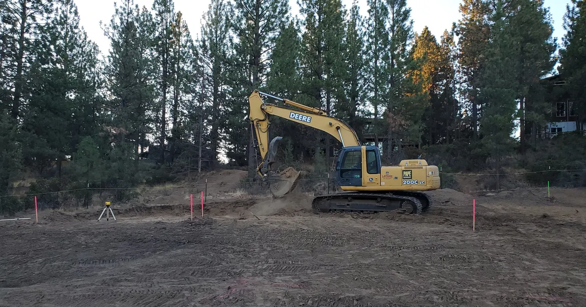
Last reviewed: 2026-11-06. Flood rules vary by jurisdiction and change, so confirm with your local floodplain administrator.
A customer brings you a lot in a flood zone, and you price the house like any other. The floodplain development permit is where that plan meets the local rules, and in many places it settles the survey, the fill and the design before the building permit moves.
A floodplain development permit is a local permit that a city or county issues for development in a mapped flood zone. It usually comes before or alongside the building permit. The review can be a staff review or a conditional use permit, so confirm the path with the floodplain administrator, the local official who runs the floodplain rules.
A builder who treats it as a checkbox on the building permit can find out at submittal that the survey, the fill plan and the design have to change. Part 2 covers the elevation certificate and Part 6 covers the design sequence.
Table of contents
- What is a floodplain development permit?
- What counts as development?
- What goes in the application?
- Is it a simple staff review or a conditional use permit?
- How much does it cost and how long does it take?
- Does the building permit cover it?
- Can the state require its own permit too?
- What happens if you build without one?
- What should you check before you buy or design?
- What does a SiteFacts Report do here, and what doesn’t it do?
- Terms on this page
What is a floodplain development permit?
It is the local permit that controls development in a mapped flood zone, and the city or county issues it, not FEMA. The Federal Emergency Management Agency (FEMA) maps the hazard and sets the minimums. The community adopts the ordinance and runs the permit.
The federal rule is 44 CFR 60.3(b)(1) and (c)(1): a community in the National Flood Insurance Program (NFIP) must require a permit for all proposed construction and other development in mapped A zones, whether or not a base flood elevation (BFE) is published. That covers Zone A, AE, A1-30, AH and AO. CFR is the Code of Federal Regulations.
Those are minimums. Under 44 CFR 60.1(d), state or local rules that are more restrictive “shall take precedence.” The local ordinance controls, and Part 1 shows where this permit sits in the build sequence.
What counts as development?
Any man-made change to the land, not only a house. 44 CFR 59.1 defines development as “any man-made change to improved or unimproved real estate, including but not limited to buildings or other structures, mining, dredging, filling, grading, paving, excavation or drilling operations or storage of equipment or materials.”
Each community’s ordinance sets which items need a permit, and local lists run well past the house.
Wake Forest, North Carolina, lists clearing, fill, grading, excavation, drainage and culvert work, road construction and an individual water or sewer system as other development on its permit application. In Delano, Minnesota, floodway uses that “may be allowed with a permit” include roads, driveways, culverts, and grading and filling, under Floodplain Ordinance O-24-05.
Weld County, Colorado, exempts only uses that “do not require structures, do not require alteration of the floodplain such as fill, excavation, or permanent storage of materials or equipment,” per its June 2026 procedural guide. Fill, excavation or permanent storage of materials or equipment takes a use off that list.
Small work can get a lighter track. Garden City, Idaho, has a Minor Work Floodplain Permit for exempt work outside the floodway, such as an accessory structure under 200 square feet and under $7,500, a stored RV or a fence.
In our experience, if it moves dirt, adds a structure, paves or stores material in the mapped floodplain, expect the floodplain permit to apply. Sheds and fences often have a short form path. The local ordinance decides, so ask before you start.
Raising the ground is development too. Where a community has an adopted floodway, 44 CFR 60.3(d)(3) has it prohibit encroachments, including fill, unless engineering analysis shows no increase in flood levels. Local rules on fill can be stricter, and bringing in dirt does not skip the permit.
What goes in the application?
In the forms we read, the application asks for a site plan that shows the flood boundaries and the BFE, elevation data for the building, and, in a floodway, an engineer’s no-rise certification. Each jurisdiction sets its own list.
Parker County’s undated instructions want the BFE and the proposed lowest floor on the building design plans. Weld County wants the floodplain and floodway boundaries on the property, the BFE at the building site and the lowest floor elevation, including a basement or crawlspace. For a new house, Wake Forest wants a certified FEMA elevation certificate with the proposed lowest floor elevation and a foundation plan.
For a floodway, Parker and Weld require a no-rise certification, and Wake Forest’s form asks whether one has been obtained.
Delano’s ordinance says the no-rise analysis is performed by a professional engineer and is “commonly documented through a ‘no-rise certification.’”
The reviewer checks your other permits too. In mapped A zones, 44 CFR 60.3(a)(2) has the community confirm that required federal and state permits are in hand, including Section 404 of the Federal Water Pollution Control Act amendments.
Elevation certificates come in stages. Weld County asks for a pre-construction certificate with the application, one after the foundation is done, and an as-built certificate before the certificate of occupancy or final building permit approval.
In our experience the sequence runs in this order. A surveyor surveys the site and stakes the BFE there, then the permit goes in with the fill and grading shown on the plan, then the surveyor certifies the fill and the floor as built.
Is it a simple staff review or a conditional use permit?
It can be either, and the local ordinance decides. In our experience, these permits vary widely, from a simple planning review to a full conditional use permit.
At the staff end, Weld County’s fee table lists its floodplain permit under “Administrative Staff Review.”
At the other end, Delano, Minnesota, subjects some designs to a conditional use permit. Section 6.21.B of its Floodplain Ordinance O-24-05 says, in its flood fringe district, “Elevation methods alternative to these fill standards are subject to a Conditional Use Permit.”
Minnesota’s state rule points the same way: Minn. R. 6120.5800 subp. 4.B has a residential first floor ordinarily go on fill at or above the flood protection elevation, and says floodproofing or other protective measures “may be allowed only upon issuance of a special use permit by the local governmental unit.”
Oregon offers one example in the middle. Lane County’s Ordinance 21-07 (2021) says new dwellings must be located outside the special flood hazard area (SFHA) unless the applicant shows that is infeasible. Some of those cases go through a Type I review, and cases that need discretion go through a Type II review. It covers unincorporated Lane County only.
How much does it cost and how long does it take?
It depends on the jurisdiction. There is no national average, so ask the floodplain administrator for the fee schedule and the review time.
Official examples follow. Each is as of its document date, so confirm before you budget.
Weld County’s June 2026 procedural guide lists a $300 fee for administrative staff review, and lists 45 days beside it. Permits that need extra analysis list at $750. Wake Forest’s May 2022 form lists a $100 fee, and says fees can change without notice.
Those fees cover the permit only. The surveyor, the engineer and any studies are separate costs that depend on the lot.
Does the building permit cover it?
In the places we read, no. The floodplain permit and the building permit are separate approvals, and one does not stand in for the other. Confirm how yours is set up.
Weld County’s guide says a Floodplain Development Permit shall be obtained for all development, buildings or structures in the floodplain “regardless of building permit requirements.” That means work with no building permit, such as fill or a driveway, can still need the floodplain permit.
Ada County, Idaho, lets you apply for both at once. Its page says the building permit will not be issued until the County Engineer approves the floodplain permit.
State or federal permits can come first. Delano, Minnesota, says work in public waters needs a Department of Natural Resources permit, or a showing that none is required, before applying for a local permit.
The permit can also follow you to the end. Wake Forest’s form says no work may start until a permit is issued, and that development shall not be used or occupied until final approval is issued. In our experience, floodplain approval usually comes first, and the as-built elevation record usually gates occupancy.
Plain words for your customer: “The local floodplain office usually looks at what the project does to the floodplain before it looks at the house plans. That review can change the plans, so we start it first.”
Can the state require its own permit too?
Yes, in some states. The state floodplain office tells you whether a state permit applies on top of the local one.
Illinois Department of Natural Resources says construction in the floodways of streams must be permitted by the state before construction where the drainage area is one square mile or more in urban areas, or ten square miles or more in rural areas. Where no floodway has been delineated, it generally requires permits for work anywhere in the floodplain.
Minnesota’s public waters work permit, which Delano’s ordinance cites under Minn. Stat. 103G.245, is a second example. Ask early whether a state permit applies.
What happens if you build without one?
The structure can be presumed in violation. Under 44 CFR 59.1, a violation is the failure of a structure or other development to be fully compliant with the community’s floodplain management regulations. A structure or other development without the elevation certificate or other certifications the regulation requires “is presumed to be in violation until such time as that documentation is provided.” A missing elevation certificate or no-rise certification can trigger that, even if the house was built high enough.
Section 1316 of the National Flood Insurance Act says no new coverage shall be provided for a property the Administrator finds has been declared by a state or local authority to be in violation of floodplain laws, per 42 U.S.C. 4023.
That is not automatic. FEMA’s glossary says Section 1316 was intended primarily as a backup for local enforcement, and that it will only be implemented where states or communities submit declarations for that purpose.
Communities carry risk too. A community that fails to adequately enforce its floodplain rules can be put on probation, and FEMA must first tell its policyholders about the impending probation and the additional premium, under 44 CFR 59.24(b).
If a community grants a variance, 44 CFR 60.6(a) says it is for floodplain management purposes only and that premium rates will not be modified by it, so a variance does not change how the premium is rated. Part 4 covers flood insurance.
What should you check before you buy or design?
Check the map, then call the administrator, then design. This is the order we suggest to builders and land buyers.
- Confirm the current effective flood map for the lot, with the panel number and date. Maps change, so recheck before design and permit. See Step 1 in Part 1.
- Call the floodplain administrator. Ask which permit path applies, how long it runs, and what the application needs.
- Have a licensed surveyor stake the BFE on site. SiteFacts’ advice is to do this so you and your customer can see what you are working with.
- Plan any fill with the jurisdiction before you design around it.
- Design the house with the floor height and fill answers in hand, as in Part 6. Plan for elevation certificates at each stage the jurisdiction sets, as in Part 2.
What does a SiteFacts Report do here, and what doesn’t it do?
A SiteFacts Report flags the mapped flood zone and the overlays that apply to a lot. Each report is analyst verified and typically delivered in 7 to 10 business days.
It does not survey a lot, prepare an elevation certificate, prepare a permit application or decide the permit path. A surveyor or engineer does that work, and the floodplain administrator decides what the lot needs.
See the flood zone and overlays on the lot before you quote
See the SiteFacts Report for your lot before you quote. The permit path remains the floodplain administrator's call.
Terms on this page
- Development: any man-made change to land, including buildings, filling, grading, paving, excavation and storing equipment or materials.
- Floodplain administrator: the local official who runs the floodplain rules and permit.
- No-rise certification: an engineer’s statement, backed by analysis, that development in a floodway will not raise flood levels.
- Conditional use permit: a permit for a use the ordinance allows only after added review and conditions.
- SFHA (special flood hazard area): the area on the flood map with a 1 percent chance of flooding in any year.
- BFE (base flood elevation): the height floodwater reaches in a flood with a 1 percent chance of happening in any year.
Checklist: Flood Zone Build Checklist
Print this page and keep it with the file for any lot in an inland A zone, which is a mapped high-risk flood area whose flood letter starts with A. Each row names who to call, the document that closes the step, and where our guide explains it.
This checklist follows the guide for one- and two-family homes in inland A zones. Coastal V zones, Coastal A zones and manufactured homes have their own rules and are not covered.
The lot
- Address: ______________________________________________
- Current FIRM (Flood Insurance Rate Map) panel number: ______________ Effective date: ______________
- BFE (base flood elevation): ______________ Required freeboard (extra height above the BFE): ______________
- Floodplain development permit number: ______________
| Done | Step | Who to call | Document that closes it | Guide |
|---|---|---|---|---|
| ☐ | Step 0: customer told the lot is mapped and what it means: map panel, BFE, permit and insurance | Local floodplain office | Address checked on the Federal Emergency Management Agency’s (FEMA) Flood Map Service Center, floodplain office called, blanks above filled in | Step 0 |
| ☐ | Step 1: current flood map pulled, and pulled again before design and before the permit | FEMA’s Flood Map Service Center, then the floodplain administrator, to ask whether a map update is pending | Current effective FIRM panel, with panel number and date | Step 1 |
| ☐ | Step 2: local permit started, since it governs everything after it | Floodplain administrator | Floodplain development permit | Step 2, Part 7 |
| ☐ | Step 3: surveyor hired; staking the BFE on site is recommended | Licensed surveyor | BFE stake, and the elevation certificate (EC) at the stage the jurisdiction requires | Step 3 |
| ☐ | Step 4: floor height set at the BFE plus the local freeboard, with the subdivision plan read too | Floodplain administrator | Freeboard number in the blanks above | Step 4 |
| ☐ | Design: foundation wall height, crawlspace depth, vents, stairs and equipment worked out from the floor height before the plan is final | Floodplain administrator, and an engineer if the design calls for one | Foundation plan reviewed with the permit | Part 6 |
| ☐ | Step 5: materials below the BFE chosen to hold up in floodwater, with flood openings planned and mechanical equipment, including outdoor units and garage equipment, located to meet local rules | Floodplain administrator | Confirmed with the floodplain administrator that materials below the BFE, flood openings and equipment location meet the local rules | Step 5, equipment |
| ☐ | Step 6: any fill planned with the jurisdiction, because fill is regulated and does not change the map by itself | Floodplain administrator | Local approval for any fill, confirmed with the floodplain administrator | Step 6 |
| ☐ | Step 7: septic tank anchored against floating | Licensed septic designer and the local permitting office | Tank anchoring detail | Step 7 |
| ☐ | Step 8: end of construction closed out | Licensed surveyor and the floodplain administrator | Final (as-built) EC | Step 8 |
| ☐ | Insurance: quote in hand before the customer commits, since meeting code does not set the price | Insurance agent | Quote, with the EC | Insurance |
No BFE printed on the map? Ask the floodplain administrator how the elevation is set. Basements and the 50 percent rule for remodels are in the full guide.
Read the full guide. A SiteFacts Report flags the mapped flood zone on a lot, but it does not survey, prepare an EC, or set the floor height. Flood rules change and vary by jurisdiction, so confirm each step with your local floodplain administrator.